 |
FROM THE FORTH TO THE TAY
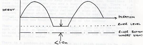
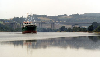
The following accounts ‘Port Edgar to Perth’ by the late Captain Alister Preston and my ‘Bo’ness to Perth’ are intended to encourage venturing round Fifeness. I was lucky enough to do the RYA shore based courses at Forth Valley College, Falkirk when they were presented by Captain Bill Hodgson with Alister assisting. Bill gave the merchant navy slant and Alister chipped in with aspects of special interest to the small boat sailor, bringing along gear from his own boat. They were most entertaining evenings. Both could tell great stories of their time at sea but each evening we were brought back from Maracaibo or the South China Sea to learn some navigation, their teaching being the best accessory I have ever bought for my boat. Alister’s sea time had included running cargoes of aviation kerosene up the coast of Vietnam during the Vietnam War so was especially lively. His boat, Kergord, is a Lone Gull II designed by Maurice Griffiths, the foremost designer of shoal draft cruising yachts. With a draft of 3ft 4ins, long iron ballast keel and wooden bilge keels, Kergord is well suited to shoal water exploring. The Tay estuary has fast flowing tides and shifting sandbanks, familiar features to MG on the English East Coast rivers during his designing years. Alister’s account which I have titled “Port Edgar to Perth” is an extract from a personal letter and reproduced by kind permission. It has the freshness of a small boat log with the observations of a very experienced professional navigator. He wrote: Port Edgar to Perth I have just returned from my trip to Perth which I had promised myself. I’ll regale you with my adventures. Having sailed from Port Edgar on an ebb tide (maybe the last of the flood), I slipped into Elie for my first night to telephone home and receive crew, a young lad and his father. Needless to say I cut it too fine and grounded in the visitor’s berth at the inner end of the mole but about 3m from the ladder. Fortunately a good Girl Guide tied a couple of ropes for me but I had to wait till the early morning to get alongside. There has been a lot of money spent on the waterfront at Elie. The Elie and Earlsferry SC have a new clubhouse with clubroom, kitchen, showers, telephone, parking etc. When we left Elie it was so cold that the crew started to suffer. They wanted to brave it out but that is no way to round Fifeness for the first time so – into St Monance, a first visit for me. The leading lights into the harbour mouth have been removed. Just depend on the beacons on the pierheads. The FYCA Pilot Handbook says that a telephone box on the waterfront is a good lead through the harbour mouth. This might have been the case when the telephone box was a good honest red but now that the box has been replaced by a stainless steel one, it is far from obvious. You know the one about being a bilge keel boat in a steep sided river in case one keel falls into the abyss? Well I had it in St Monance harbour with an old keel scar in the mud alongside the quay. We lay there at an angle of about 45 degrees for 4 hours. Not at all pleasant! At least at low tide I was able to identify the cause. We had a cracking good sail in a SE breeze up to the Tay and crossed the banks at the Abertay buoys. The locals told me later that I should not have done that but go up to the “Middle Buoy”. The banks are very unreliable as charted. Certainly, the ebb tide which was still flowing was very strong. The up river sail was another real cracker and I carried on up the Tay on the first of the flood, too early. I stopped below the bridges to get the sails down before motoring up river. They have a predilection for porthand buoys on the Upper Tay. I think there is only one starboard hand buoy all the way up to Perth. The buoys must be read intelligently and followed absolutely. The Admiralty chart is not a lot of help, just a thumbnail sketch which says “channel is buoyed”. To leave early with my boat was alright but others could have a problem. I grounded a couple of times on small stones but lifted off on the rising tide. From my own deduction, the tidal curve at Perth appears to be as below:
There is absolutely no point in leaving Dundee earlier than 2 hours, say 2 ½ hours before HW Dundee. Also, the duration of the peak at Perth is very short, barely enough time to allow the pilot to turn the ship round and back it into the berth. Loaded ships always take the bottom (mud) shortly after HW and happily discharge while aground. The port is busy importing material for United Glass at Alloa. Forth Ports Authority killed Alloa by removing the buoys in the river above the Kincardine Bridge. Last year Perth had 220 ships and imported 270,000 tonnes of cargo. Not bad for two little berths. There is no place for a yacht to tie up in Perth. I managed one overnight because I arrived after the working day was over but the harbour master asked me politely to leave next morning before the arrival of a ship. He expedited me by saying the overnight charge was £25. After passing under the high level road bridge below Perth, one is faced with Willow Island (Moncrieff Island) which earns its keep by supporting the local golf club. The main channel is the one to the left. This leads up to the commercial port which is built of sheet steel piling with occasional fenders fitted vertically. A yacht’s gunwhale could become trapped under one of these fenders. There is no facility for putting a yacht alongside at Perth although at Tayport I was told that it is permitted to berth where the sand dredger ties up to discharge. Great piles of drying out sand abound and surely half of them will try to climb aboard. There is a hole on the SW side of Willow Island which gives anchorage in about 3m so the answer is to take a dinghy. I came back down the river in the dark. The buoyage is adequate for this but you have to keep your wits about you. Sometimes it pays to remember where you saw a buoy on the way up. There is a remarkable dog-leg just up river of the Tay railway bridge, for instance. There is a highly reflective sign at the entrance to Tayport harbour which says just that. It is easily found with a strong light while the harbour mouth is hidden by background lighting from new housing at the head of the harbour. There are four watering points in Tayport, one is at the head of each of the two slipways on the starboard side and two on the tying up side at 1/3rd and 2/3rds of the length of the quay, both with hoses, beautiful water. There is a pontoon on the port side wall which seems to be fully occupied by smaller boats from the local club, The Tay Corinthian Boating Club. This releases more of the quay wall for the bigger boats and visitors. Public toilets have been built at the harbour entrance on the west side. The club intends to put in another longer pontoon and to build a clubhouse. There is a bar at the entrance but boats can stay afloat alongside the steps just inside the east wall. At the foot of the outer slipway there is a large flat ledge. It is very large, the sort of facility that would allow a fishing boat to dry out for propeller inspection etc. When this covers, there is enough water to enter. I could not get anybody to specify draft but the boats are 26 ft to 30 ft bilge keelers. Take it from there. Tayport is a little harbour on the way up. This is just as well because it is the only harbour in the Tay. That may be a broad statement but it is true. Broughty Castle has a rock bottom and I cannot think of any other harbour. We might think we have problems on the Forth but in the Tay yachtsmen have nowhere to go, except maybe the Forth. I came out of Tayport with plain sail in a SE 2-3 and on the ebb tide. This was fine until I cleared the drying banks at the Abertay buoys. With wind against tide and an increase to force 5 the slop was huge and confused. I got soaked and instantly cold. Rather than become an incident and since I was solo I turned back to Tayport. The locals refer to the stretch between the Abertay and Middle buoys as the “Mad Mile” or the “Dirty Mile”. All in all it was a successful and enjoyable trip. The wildlife is burgeoning among the reed beds and on the banks and the scenery is gorgeous. The brown, peaty water of the upper river is very clear and we noted only one sewage outfall. If I do the trip again it will be to look at Bridge of Earn. Captain Alister L. Preston Yacht Kergord 2002 From the Forth to the Tay is only a day sail but rounding Fifeness, picking up the Tay entrance buoys and crossing the bar is sufficient to deter many leisure sailors. I have to admit I by-passed the Tay to begin with but eventually discovered interest abounds in both Firths. The variety of navigational considerations on this trip will rehearse most of the RYA day skipper course, passage planning, tidal calculations, pilotage and rule of the road. Blue Spindrift left the mooring at Bo’ness on the last of the flood, an easterly wind bringing uncertain visibility. After a long winter, late launching and months office bound, whatever the menu it would be enjoyed, as Scots say “Hunger’s good kitchen”. The lateness of the tide meant the North side of Inchcolm Island, below the Abbey, was the first anchorage, all to oneself on a Saturday evening. Lonely too it must have been in 1123 when King Alexander I blown off course by a south westerly gale, took refuge here and built the original Augustinian Priory in thanks for his deliverance. A misty day dawned and an early start was made. Off St Monans this proved its worth as a wall of fog advancing up the Forth chased me back to Elie to anchor, rather than enter the harbour and take the ground till late morning. This attractive sandy bay has one drawback; it does its best to develop your sea legs. Leaving a warm bunk for mist and a headwind I asked myself “Why do I do it?” but answers were not long in coming. The skies cleared for views of the Caplie caves, sculpted red sandstone of the lower raised beach. Having rounded Fifeness, off St Andrews where the University is home to the NERC Sea Mammal Research Unit a minke whale surfaced alongside the boat. SMRU uses telemetry to track seals, employing mobile phone technology.
Being fair weather I headed for the Abertay South buoy to clear the sands which extend well offshore. Little of these were visible being mid tide, the flood being timed for passage up the Tay. In less favourable conditions one is advised to head for the Middle buoy. The stretch between the Middle Buoy and the Abertay is known as the Dirty Mile or the Mad Mile, comment enough
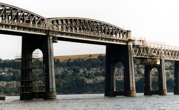
A dredger was busy in the estuary collecting sand for the Readymix quay at Perth. To the west the sun was sparkling on the water and between the Inner Buoy and South Lady were two pods of dolphins. The Tay entrance is guarded by Broughty Castle dating from 1498 and was looking the part in the sun, saltire streaming from the tower. The buoyage leads to the appropriate navigation spans of the bridges, under the triangles on the Road Bridge and the second and the fifth from the South of the high girders of the Railway Bridge. The buoyed channel makes some remarkable doglegs but the buoys are substantial, mainly porthand. Gazing up at the high girders one imagines the scene in 1879 when 1060 yards of this section of the old bridge, a train and 75 souls fell 80 feet into the icy black water of a stormy night. On the south side, east of the road bridge stumps of the piers of the old bridge can still be seen but are better viewed from the shore or a train crossing the bridge (1).
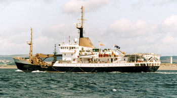
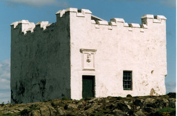
It is as well I was looking for an anchorage as Dundee docks or Tayport harbour are the only alternatives barring piers and club moorings. The Forth yachtsman is rather more fortunate in his choice of harbours. There is plenty of nautical interest in Dundee. The RRS Discovery, Dundee built, the frigate Unicorn (2) (the oldest British ship afloat) and the North Carr Light vessel (3) are on public display. The latter is dedicated to Admiral Thomas Cochrane 1775-1860 (4). Brought up in Culross on the Forth he made his name fighting some extraordinary actions in South America and against Napoleon’s navy. The fore topsail of the Victory, the only known surviving sail from the battle of Trafalgar was made from canvas woven in Dundee and besides the weaver’s marks bears 90 shot holes from the battle (5). I continued up river chart in hand, thumb on the last buoy passed to anchor off the ruined pier at Balmerino. It is a pretty village with a ruined abbey, a Cistercian monastery founded in 1229. All that remains standing is part of the chapter house with arches and vaulted ceiling, a pretty spot to look round being surrounded by ancient trees, some dated by coring. A quiet night with wisps of cirrus followed, sleeping soundly thanks to my trusty Bruce anchor in good holding, in spite of the pull of river current and spring ebb. Going ashore in time to step from the dinghy onto the stones of the ruined pier, the mud was avoided. Balmerino has a cemetery with imposing memorials and a freshwater tap but wanting postcards the nearest shop was at Gauldry, three miles away. The signed footpath, “The Monks’ Road”, petered out but once back on the tarmac a friendly local stopped to give me a lift. The walk back was worth the view of the extensive muddy shoals on the North side of the river. Above the bridges the chart is of limited utility and the Forth Yacht Clubs’ Association Pilot Handbook essential (6). The tide was now flooding and two hours before HW Dundee I left for Perth. The tidal curve at Perth is one of 4 hours rise, 4 hours ebb and about 4 hours low water stand, depending on the river level. The weather was misty and wind light but yachts motor this stretch. Up river approaching Mugdrum Island one closes the reed beds, the most extensive in the UK and formerly harvested by the Tay Reed Company. The reeds are important bird habitat and full of life. The TRC closed in 2005 and the cutting of reed to maintain the bird habitat is being continued by the RSPB. In the lower reaches, the Tay flows past flat farmland but nearer Perth it is flanked by magnificent highland scenery.
Here one gets an impression of the size of the river, having greater freshwater flow than the Severn and Thames combined. On the Tay, one of Scotland’s premier salmon rivers, a Miss Ballantyne caught the record 64lb fish in 1922. Today 30lbs plus fish are caught each year. The season is from January 15 to October 15 with no fishing on Sundays. I didn’t see a single rod but there were salmon cobbles on their moorings. On the lower reaches one passes numerous derelict salmon lodges, cottages from which salmon net fishing was formerly carried out by the estates. There are also more castles including Elcho, now almost hidden by trees, although Lord Elcho is perhaps better known for his bayonet design than his castle. The channel comes close to Newburgh and then swings mid river. Approaching Newburgh the buoys give way to beacons. One appeared to have been hit and was leaning over just clear of the water, a buoy having been laid beside it. I had not got round to phoning the Perth Harbour Master to ask about shipping movements. Rounding Sleepless Inch two large coasters were bearing down at speed and I hurried to the North bank out of their way. Vessels leaving Perth have to get down the 16 miles to the sea quickly while they have the water and with their momentum can slide over sand bars.
Perth harbour is a small but busy port (7,8,9). There is no room for yachts but one can anchor in the nearby Willow Channel. Here colourful flowers cascaded into the water but the high level road bridge with traffic streaming by felt oppressive. I decided to go back down the river while there was water, though I did consider anchoring in the mouth of the River Earn. Going back with the ebb had the advantage of following the channel while the marks were still fresh in my mind. I anchored off the derelict lodge on Flisk Point, just a few miles up river from the previous evening. By half past midnight the wind was a fresh westerly. Whilst noisy there was not a lot of motion and later riding to the ebb the boat was quieter. I was glad I had taken the trouble to hoist a riding light when another coaster from Perth went by.
The morning brought sun and continuing fresh westerly. I was soon heading out to the Abertay South buoy. Being nearly low water the channel was flanked to the South by the Sands with large groups of seals hauled out. From a distance they could have been mistaken for rocks. On the North side off Buddon Ness one of the coasters that passed me was lying at anchor and a Northern Lighthouse Board vessel came in.
A good sail was had back to the Forth. Rounding Fifeness, potmen dodging between the North Carr Rock and Tullybothy Crags in the sunshine belied the danger of the place. The beacon on the North Carr was designed by Robert Stevenson and constructed of six cast iron columns topped by a ball. Having lost 15 courses of stone in a storm during construction the beacon was built on the remaining five and completed in 1821.
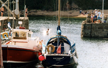
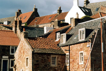
The fresh westerly now on the nose I was glad to be able to go into Crail. A small fishing harbour, Crail is largely bypassed by yachtsmen as neighbouring Anstruther provides facilities for yachts. The harbour was busy with visiting painters and photographers, intent on capturing the traditional architecture with its red pantile roofs and crow stepped gable ends. Extensive areas of the original dry stone quay walls remain, the oblong stones placed vertically. In recent years collapses have occurred when dredging the harbour. Repairers have laid the stones horizontally. In the evening I walked up the ‘Hen’s Ladder’, a cliff path to the high street that follows a recently rebuilt retaining wall.
In the morning I left in bright sun under a clear blue sky with a moderate leading wind to the Isle of May, perfect sailing weather. Formerly the lower light on the May in transit with the main light gave the clearance line for the North Carr Rock. Anchoring off Kirkhaven I went ashore. The pier was piled with rusty pieces of the Bailey bridge, just cut up, that had spanned the gap to Rona. Five hours on the May exploring in the sunshine was an encouraging end to this trip. References
Paul Shave Yacht Blue Spindrift 2003 Revised October 2011 |
info@fyca.org.uk
©dss2016