 |
CAIPLIE CAVES AND THE HERMIT’S WELL, KILRENNY, FIFE
 |
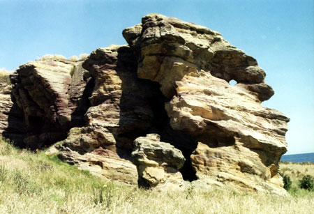 |
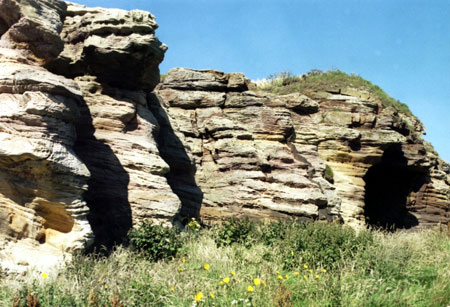
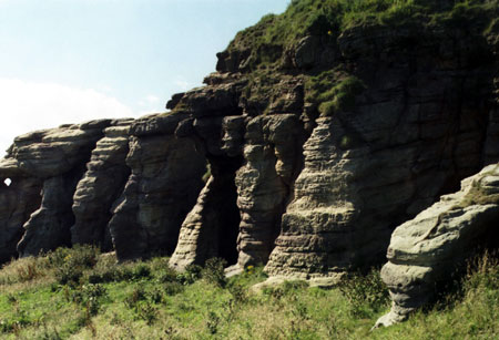
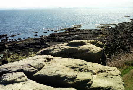
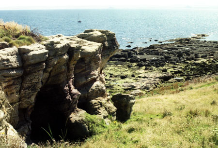
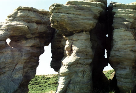
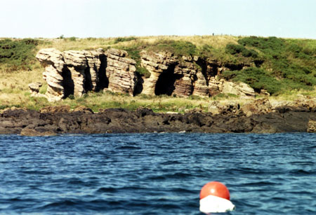
Halfway between Anstruther and Crail are the Caiplie Caves, locally known as “The Coves”, short lengths of passage in a prominent, spectacularly weathered, calcareous sandstone outcrop on a raised beach level. It is the only outcrop in this vicinity. A conspicuous dark cave mouth is visible from seaward. Incised crosses and other symbols suggest early Christian and Pictish use and the caves have been the subject of academic interest (1,2). St Adrian is associated with them. Like the East Wemyss caves, those at Caiplie repay some preparation before visiting and without which detail will be missed. The papers noted above are recommended. Knowing what one is looking for is important as the smokey, vandalised interiors are inclined to deter curiosity. This is compounded by the challenge of getting ashore and keeping half an eye on the weather for the return to the boat. Familiarity with these caves fixes another landmark in the mind of the coastwise navigator. Their story is an interesting one and visiting by sea can be a challenge. A morning visit is preferable as sea breezes are more likely to get up with the heat of afternoon sun and can complicate regaining the boat. This striking geological feature with its social history makes an interesting excursion and one that should not be put off as the proximity of the coastal footpath exposes the soft stone to accelerated mindless destruction. Anchor in 5 metres and take care to avoid the numerous creel markers. Landing is difficult due to sharp reefs running out to the south west and the rocky foreshore. At half tide I found one of these reefs to the south west of the caves provided some shelter for flat rocks where the dinghy could be hauled out. My visit was a lesson in how quickly sea conditions can change here. In the caves, holdfasts, small excavations in the rock permitting rope to be threaded through to hang things up are fairly obvious. Incised markings need careful shallow angle lighting to throw them into relief and discriminate from the modern additions. The axis of the main cave is NW-SE and most of the markings are on the NE side. One can scramble onto the top of the outcrop which provides a viewpoint for this stretch of coast. If children are in tow there is loose rock and steep drops are deceptively hidden by the curvature of the edge. A boiler suit, cap lamp and companion are advisable if one intends to reach the cave extremities described below. For a casual entrance look-see caving equipment is not necessary. A torch is useful and a woolly hat protects from bumps. Tony Oldham (3) in his pioneering caving guide for Scotland catalogues the following caves numbered from NE to SW, from which I quote, some of his references follow: Altitude 10 feet except cave number 1. 1. A. 20 feet; L. 50 feet a small entrance, about three feet square, opens out into a passage 8 feet high. After 20 feet the passage drops to 2 foot 6 inches high and after another 10 feet it descends to 18 inches high for another 20 feet. 2. L. 12 feet; Entrance 12 feet high and 4 feet wide. 3. L. 30 feet; Entrance 15 feet high and 10 feet wide leads to a roomy flat floored chamber with the remains of a stone wall at the entrance. This is probably the Chapel cave where St Adrian made his home in the 9 th century. On the walls are a number of crosses, one of a Greek design, but most of them are of a Latin style. An 1841 excavation produced remains of deer, boars tusks, bones of cattle and a human skeleton. In the south wall, a low doorway with a curved arch, has been chipped out of the soft rock into an adjoining cave. The same wall also shows signs of having been squared up with a pick. On the north side of the cave are a chimney, fireplace and a shelf. 4. to 6. A series of weathered archways with some stone foundations at the entrances, just visible still.
References Glasgow Herald 4 August 1955 Gentleman’s Magazine Part 2 1865 Gloucester Speleological Society 1 (4) Jackson, Rev. John, ND [1946] Official Guide to Crail, revised by J Gordon Dow. Illustrated, pp 60. Stuart, J (1867), Sculptured Stones of Scotland, 2, p89-90 and 129.
My time was limited so I did not find the Hermit’s Well marked on the OS map. This may just be a synonym for the caves but the separate map reference in the RCAHMS database suggests otherwise, something to resolve on a future visit. References 1. Royal Commission for Ancient and Historical Monuments Scotland database – Archaeology Notes and 13 item reference list. http://www.rcahms.gov.uk/pls/portal/newcanmore.details_gis?inumlink=34025 2. Joan E.L. Murray (1963), “Rock-cut symbols in Caiplie Caves”, Proceedings of the Society of Antiquaries of Scotland, 94, 1960-61, 324-5 includes a photograph of the incised markings in Chapel Cave. http://ads.ahds.ac.uk/catalogue/adsdata/PSAS_2002/pdf/vol_094/94_324_325.pdf 3. “The Caves of Scotland” by Tony Oldham, published by Tony Oldham, 1975. Paul Shave yacht Blue Spindrift 1 September 2007 |
|
info@fyca.org.uk
©dss2016