 |
UPPER FORTH RIVER TO STIRLING |
|
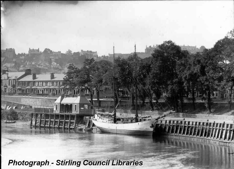
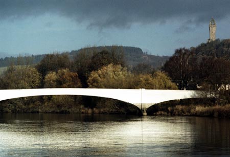
The Taylorton (Sow Ford) road bridge a mile from the city is the barrier to yachts with masts going up to Stirling. However to use the Forth and Clyde canal, boats have to lower their masts and so an exploration further up river can be conveniently fitted in with a canal transit. The upper river provides a refreshing contrast to the estuary. River navigation requires careful planning due to the challenges from the additional variables of volume of river water and moving mud banks. The reed beds are full of wildlife and once the industry has been left behind the Forth presents a very pretty rural scene, with views of the Ochil hills and farmland of prime lowland richness. Stirling Town Quay is in a small public park in a quiet desirable residential area of the city. Boats lying alongside with masts down are out of sight of most passers by and this tree lined haven is a short walk from the centre of an historic city with all the trimmings, a rock perched royal castle, wonderful medieval church, majestic riverside abbey, climacteric battleground and city walls that made a statement. In a compact compass the ancient contrasts with the modern university, cultural infrastructure and varied shopping experience. Stirling Town Quay - history From 1450 Stirling was well established as an important port (1,2), centrally located, surrounded by rich farmland and with a sheltered berth. The vessels of those days were small enough to pass the shallow fords, though going up river against the current the meanders ‘the windings’ were a trial for sailing ships and some were already unloading at Airth. Over the period 1603 - 7 improvements were made to the quay but from 1603 the strategic importance of the town was declining with political change. The main exports were cloth and skins and the imports tallow, bark, lime, wool, wine and timber. The latter from Norway where they had introduced the circular saw. The windings and fords restricted further development, 70 tons being the vessel limit and trade fell in the 17th and 18th centuries. In the 1820s the Stevensons of lighthouse fame cleared a deeper channel through the fords by blasting and the vessel limit rose to 300 tons. Further improvements made in the 1850s were too late, the railways had arrived. Ship building, an industry all the way up the river began to decline in Stirling in the late 1850s due to the constraints to navigation. James Johnson’s yard launched the 500 ton clipper Stirling in 1852 and the 1,000 ton William Mitchell in 1856. In the 1920s and 30s small freighters continued to make the awkward voyage up the windings over the shallow fords but trade ended with the 1939 war. Over the centuries a ferry had operated between the town and Cambuskenneth linking the castle and the abbey. In 1935 this came to an end with the construction of a concrete footbridge. As the Pilot handbook says, the piers that were used by these ferries have gone but archaeological traces remain, three and four courses of stone visible at low water if one can get through the vegetation. The remains of these piers and many others round the Forth are documented in coastal assessment surveys carried out for Historic Scotland (3). This report and others of interest to Forth sailors are on the SCAPE TRUST (Scottish Coastal Archaeology and the Problem of Erosion) website. Climate change is now a driver of their work. During and after WWII, traffic continued to the Admiralty pier just downstream of the Town Quay, linking the torpedo workshop with the munitions depot at Bandeath and bases of Rosyth and Port Edgar. The size of the timbers of this pier give an impression of the weights that were handled. The workshops have disappeared under the Riverside development, up-market flats with balconies overlooking the river.
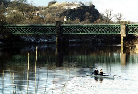
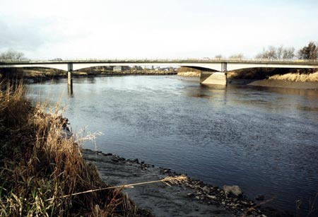
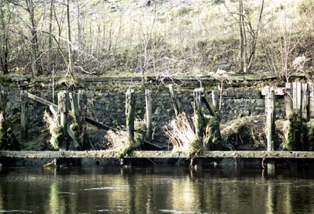
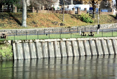
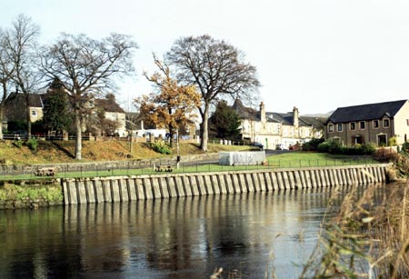
An historical competitor for Stirling Town Quay – the pow of Airth The pow of Airth (4), the mouth of the Pow burn at Higgins Neuk, had been an important harbour at least as long as Stirling, being unencumbered by the windings and not impeded by so many shallow fords. However during the reign of James IV (1488 – 1513) it became a royal dockyard (1), fitting out vessels in greater security than was possible at the more coastal deeper water facilities where they were built. With the rise of the dockyard Airth seems to have maintained its importance as a trading port. Ships fitted out there included the Margaret and the James and perhaps the great Michael 1,000 tons, the largest ship in Europe at the time. Land reclamation and the shifting course of the burn mean that the precise site of the dockyard is unknown. Local enthusiasts search but professional archaeologists do not appear to have been tempted to get involved in the quest, even with the construction of the Clackmannanshire Bridge close to the area. Unlike Stirling there is no surviving port facility at Airth. Stirling Town Quay - information update November 2008 The FYCA Pilot Handbook is the publication of choice for venturing up river but old editions of the Admiralty Pilot (5) give extra information on the fords between Alloa and Stirling. This is worth knowing as having had to wait for low water to get under the Kincardine and Clackmannanshire bridges and then wait for water to go up river, it is tempting to get going early, with the risk of grounding on the step of a ford. Old Admiralty Pilots say: “Between Alloa and Stirling there are seven fords or shallow ridges, which form obstructions to navigation. They are composed of boulders, embedded in a matrix of hard clay. At each ford the bed of the river rises by a step of from one to 3 feet (0 m to 0 m9, making the difference in height between Alloa and Stirling about 10 feet (3 m0) ; thus the tides which have a range of 17 ¾ feet (5 m4) at Alloa have a range of only 9 ¼ ft (2 m8) at Stirling. Vessels of up to 11 feet (3 m 4) draught can reach Stirling at springs.” The Town Quay wall is now faced with deeply corrugated sheet steel piling leaning inland and topped with concrete. There are waist high iron railings half a metre back from the edge. This refurbishment would suggest approaching with caution, taking soundings, particularly if you intend to take the ground. Bilge keelers will be used to using a lead line around the boat to check for level ground and avoid obstructions. When coming alongside, a boat hook or grappling iron would be useful to hook the railings and hold the boat against the river current while it is secured. Fender boards are recommended. There are no ladders so boats are advised to bring their own. The railing posts are solid enough to hold a small yacht, tying warps to their bases. The original cast iron bollards are still in place but are 4 - 8 metres back from the wall. Their use would create a tripping hazard in what is now a public park and mooring warps would be out of sight when aboard so using the bollards is not recommended unless your vessel’s size demands something more substantial. The end of the railings nearest the town where they join a stone wall are lowest and easiest to surmount. The steps referred to in the 1973 account below have gone. There are visible partial collapses of some of the stone retaining walls in this stretch of the river so one is advised to keep clear of them. The Town Quay is only a ten to fifteen minute walk from the city centre shops and railway station. In the park there is an interpretation board giving historical background. Corner shops can be found at 200 metres and 400 metres along Shore Road, in the direction of the Cambuskenneth footbridge. There are no facilities immediately to hand but local house holders might supply freshwater. When berthed at the Town Quay the Wallace monument is in sight and there are views of the Ochil hills. One is close to the scene of William Wallace’s victory at the battle of Stirling Bridge in 1297. Cambuskenneth Abbey is almost completely hidden by blocks of flats but may be reached by the Cambuskenneth footbridge a quarter of a mile up river. Large hares inhabit the fields opposite, lying up in the field boundaries when the fields are bare. The wooden pier at the former Admiralty torpedo workshop a couple of hundred metres down river on the town side is an unusable ruin, now little more than square timber uprights. There is no deck and dangerous bolts protrude from the single remaining horizontal timber at river level. Boats are advised to keep clear. At the downstream end of this pier is a large bore steel pipe leaning inland. Next to it a post bearing a notice has also fallen inland. The effective limit of navigation for most keel boats is the railway bridge, another 2 miles up river, under the Cambuskenneth footbridge and round one more wide meander. The Stirling rowing club is located on the final stretch, on the town side 400 metres from the railway bridge. Rowers are used to having this quiet section to themselves, taking the inside of bends as they please so oncoming traffic may have to be avoided. Coxless boats cannot be relied upon to keep much of a lookout ahead. A fog horn to hand would be a useful precaution, particularly at weekends. Much of the banking of the upper river is overgrown and visitors forcing their way ashore are warned to avoid giant hog weed, now present in extensive stands. The sap of this plant can cause painful sensitisation of the skin to sunlight. Stirling Council has a control programme in place for this noxious invasive non-native species. Care needs to be taken with the upper river as flows are very rapid on the ebb when the river is in spate, the banks are steep mud and getting out of the water could be difficult. For photographs of the river as far as the Bandeath industrial estate, please see the cruising guide section ‘Alloa Railway swing bridge at Throsk’ on the FYCA website. Since this was written there is now the new Upper Forth crossing to consider, The Clackmannanshire Bridge. Some vintage cruising notes The following jottings are from pencil manuscript found on the end papers of a copy of the North Sea Pilot Vol. II, Eleventh Edition, 1959 (3) left in the clubhouse of the Upper Forth Boat Club. It is a record of local pilotage of which the club has very few. The author is unknown. This trip was made the year before the Forth Yacht Clubs’ Association Pilot Handbook was published and before construction of the Taylorton / Sow Ford road bridge circa 1985. It is interesting to note the author attempted the inshore passage by Tullibody Inch. The trip was probably made in a ship’s lifeboat, the preponderance of leisure craft in the locality at the time. Bo’ness to Stirling 25 th August 1973 High tide at Grangemouth 13-29 hrs – 29 ft 1 inch Stirling to Bo’ness 26 th August 1973 High tide at Grangemouth 14-38 hrs 30 ft 4 inches Links and bibliography 1. Archaeological notes on some harbours in eastern Scotland, Angus Graham, Proceedings of the Society of Antiquaries of Scotland, 1968 - 9: http://ads.ahds.ac.uk/catalogue/adsdata/PSAS_2002/pdf/vol_101/101_200_285.pdf 2. Stirling: The Royal Burgh, Craig Mair, John Donald, 1990 and 1995. 3. Coastal Assessment Survey: The Firth of Forth from Dunbar to the border of Fife, Part 2: http://www.scapetrust.org/pdf/Forth2/forth2.pdf 4. Airth http://www.falkirklocalhistorysociety.co.uk/home/index.php?id=20 5. North Sea Pilot Vol. II, comprising the northern and eastern coasts of Scotland, from Cape Wrath to Berwick, Eleventh Edition, 1959
Paul Shave yacht Blue Spindrift 5 December 2008 |
|
info@fyca.org.uk
©dss2016
.jpg)