 |
FROM THE FORTH TO HOLY ISLAND
Holy Island is a national nature reserve of outstanding beauty with sheltered anchorages, archaeological, architectural and cultural interest that has drawn pilgrims and visitors for centuries. This enchanting island has a natural restorative; the ebbing tide that permits very numerous visitors access via the causeway chases them away on the flood. Twice daily serenity returns and Lindisfarne slumbers until her defences lower once again. For all its magnetism, the island lies on a committing coast. All along it are reminders of the importance of weather watching, including in 1838 the wreck of the s.s. Forfarshire of Grace Darling fame (1), in 1881 the Eyemouth disaster (2) and present day the all weather Lifeboat stations of Berwick upon Tweed, Eyemouth and Dunbar and inshore lifeboats in close proximity. Imagine my chagrin when a printer’s key stroke once turned ‘the East Coast’ into ‘the Easy Coast’, T and Y being next to each other on the keyboard. I like to set off with the past few days’ synoptic charts from newspapers or the internet to be aware of the trends in the weather. Rowing out to the mooring in a small dinghy helps attune to the weather in a way you don’t when stepping aboard at a marina. A night in one of the old pilot boat anchorages at Fidra further settles one into shipboard routine, including the Maritime Safety Information (MSI) broadcasts by HM Coastguard. In good weather, from the mouth of the Forth the fifty miles to Holy Island is a daylight sail but a string of harbours in between tempt one to make shorter hops. Most of them are rock bound so if departing when visibility is threatening, re-entry may not be possible if fog closes in. Sea fog or haar is common in the spring and early summer. Eyemouth in particular has excellent facilities for passage making yachts and a wealth of attractions for crews. One should try to speak to the harbour master on VHF or mobile phone before entering to avoid meeting an outward bound trawler in the entrance channel, “The Canyon”. Be aware that in it one cannot cross the partially covered training walls. At my base at Bo’ness moorings are severely tried in a north easterly so the opportunity to stock up with mooring components, shackles, swivels and Polyform fender buoys at the Fishermans’ Mutual Association is welcome. Local history on the town trail and at the museum includes Willie Spears and the Great Tithes [on fish catches] dispute 1855-64 and the fishing disaster of 1881. At Holy Island, the monolithic Old Law Beacons suggest the dangers of these shoal waters if visibility should deteriorate and one lose sight of them. In Lindisfarne village the Fitzroy barometer set in the wall opposite the Crown and Anchor pub is a reminder of what a singularly crucial indicator barometric pressure was in the days of sail, before one was spoilt for choice of weather information. There is still no refuge with a safe all weather approach between Blyth and the Forth. Even in light winds, bilge keel yachts may find the roll makes rigging boom preventers worth the effort. The other harbours on the way south all have their attractions. Entering North Berwick can be a squeeze, fenders out on both sides of the boat. Most helpfully, the East Lothian Yacht Club maintains waiting buoys off the harbour and makes its facilities available to RYA affiliated clubs. Dunbar has a spectacular hole in the wall entrance cut through the castle rock and an early 4 ton propeller, a memorial to local lad Robert Wilson ( 1803-1882), a contender for the title of inventor of the screw propeller. Dunbar Sailing Club also makes its facilities available to visiting boats. Others are available at the leisure pool. Burnmouth is a small fishing harbour, a quiet refuge with few facilities but has a pub up the hill, The Gulls Nest, now called the First and Last. St Abbs is a picturesque small working harbour very popular as a launch site for divers but again with few facilities for yachts. Berwick upon Tweed has a busy commercial dock, three quarters of a mile from the town centre, where yachts may berth by arrangement with the harbour master. It is intended to provide facilities for yachts at this popular holiday destination. One learns to have respect for big headlands and St Abbs Head is no exception. For comfort, good weather is needed when rounding it in a small boat and a sunny day enables one to enjoy views of the cliffs. Haar can compound the difficulties of an area thickly sown with creel markers. Going further offshore to avoid them one has to go a long way as fishermen are switching from crab and lobster to langoustine, found in deeper water.
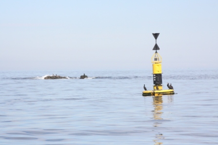
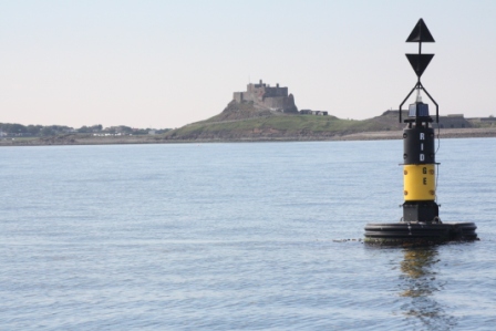
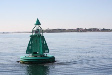
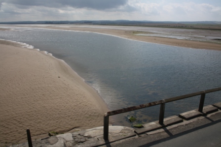
The approach to Holy Island In good conditions this coast is a fine sail with good views and, as far as Eyemouth, has a succession of prominent landmarks to peck off position. Beyond Eyemouth the coast becomes progressively more low-lying. It is wise to have compass courses on the chart, especially from St Abbs Head to avoid going too far west into the wreck strewn shallows of Berwick Bay. This is easily done as from a distance Holy Island is so low-lying it looks like off-lying rocks, more of which appear out to sea as one draws closer. Going north is easier, St Abbs Head is such a feature it is visible from the south side of Berwick bay. Approaching Holy Island there is another concentration of creel markers. As one closes the island it begins to take shape. Holy Island Castle appears on the skyline and Bamburgh Castle in a different shade of grey through coastal haze, beyond. The RNYC sailing directions (3) are the key to this coast and are very well illustrated. For more views an excellent little walker’s book packed with line drawings is Northumbrian Coastline (4) by Ian Smith and is useful for exploring. When looking for the white pyramid of the Emanuel Head beacon and not wanting to go too far out to avoid the Plough reef, the echo sounder comes into its own. Gently shelving rock and shingle extends well off False Emanuel Head and Emanuel Head.
The Heugh anchorage Having picked up the Emanuel Head beacon, one feels ones way on the echo sounder between the east end of the island and the Plough rock west cardinal buoy, heading for the Ridge End east cardinal mark. From there turning to starboard onto the transit of the Old Law beacons, keeping the Triton Shoal buoy to starboard. When the triangular beacon at the old Coastguard station and the pointed belfry of the parish church behind come into line one turns sharply to starboard onto it for the Heugh anchorage. The former CG station has recently been refurbished as a viewpoint, a new staircase and panoramic plate glass windows have been installed.
The pointed square belfry of the parish church of St Mary the Virgin is a first glimpse of one of the loveliest attractions of Holy Island. Visited when morning sunshine is streaming through the three stepped lancet east windows the stained glass is stunning. It is only 19 th century but has no less impact for that. The contrasting plain colonnaded interior appears all the more beautiful. The quiet of the place enhances its visual impact, guaranteed to make the most extrovert introspective. One thinks of the generations of mariners who have entered over the centuries to give thanks for safe arrival, heart felt no doubt for some of them after a difficult passage. The church is the oldest building on the island with stonework from the Saxon period. More than 160,000 people a year visit annually. In the churchyard by the entrance to the Priory is a memorial to a young boy, Field Flowers, who lost his life when the steamer Pegasus struck the Goldstone rock in 1843.
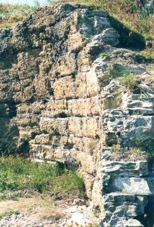
A circuit of the Heugh anchorage on the echo sounder locates where to lay ones anchor, away from a creel marker and moorings and conveniently close to the natural rock slip in front of the Trinity House store for landing. Care is needed. I have seen a boat almost stand on its nose on hitting one of the rock shelves there. On neap tides landing is straight forward. On springs the current through the anchorage limits going ashore and returning to the brief period of slack water. At such times inquiring locally can find a vacant mooring in the Ouse as on springs fishermen use moorings further out so as not to be hampered by the tide. Arriving at Holy Island is always an experience. Atmosphere is an overworked word but Lindisfarne has it. The view over the moorings to the castle in the early morning still, wisps of fisherman’s bonfire smoke hanging in the air, conveys the sentiment. The cradle of Christianity in England and the origin of the Lindisfarne gospels, it would be surprising if one did not find something special about the place. The Lindisfarne gospels is the finest book of the early Saxon period, the earliest fully illuminated English book known and one of the most splendid hand written religious books in the world. Twenty pages of it can be seen on a very effective touch screen facsimile in the Lindisfarne Heritage Centre. The original, written around 696-8 resides in the British museum. The Heugh is a dolerite dyke. Holy Island castle perches on another of its outcrops. Cuthbert’s island, The Plough reef and the Goldstone rock are all part of the same feature. This is distinct from the Great Whin Sill, the view to the south occupied by Bamburgh castle on the mainland and forming the Farne Islands dipping away to the east.
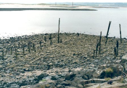
Exploring Holy Island Holy Island needs to be explored on foot, by bike or on horse back. Pony trekking is available locally. A leaflet, Holy Island A walk around the village, publisher unknown is on sale in the PO and shop. Frank Graham’s little booklet (7) also available locally is an excellent introduction. The Holy Island of Lindisfarne and the Farne Islands (8) in the Islands series, published nearly forty years ago is still useful. The main tourist attractions the Priory, the Priory Museum, the Lindisfarne Heritage Centre and the castle (9) are well treated elsewhere. All are worth visiting and I would add that the Gertrude Jekyll designed walled garden a few hundred yards to the north of the castle should not be missed. It has been replanted with species from her original plans which were discovered in California in the early 1980’s. Gertrude Jekyll also wanted plants to grow on the castle rock, Beblow crag, and had a boy lowered in a basket from the castle to plant some. History does not record whether or not they grew. Preparation for viewing the Lindisfarne gospels touch screen in the Heritage centre adds insight. The Art of Illuminated Letters (10) has a chapter on the history of illumination and shows how one of the letters in the gospels can be recreated. For those who like peace and quiet while viewing antiquities there are less publicised features of interest away from the crowds. The remains of the two old lime jetties at the lime kilns by the castle are obvious. Little known is an earlier jetty at The Basin of which only foreshore traces remain. Richard Perry’s A Naturalist on Lindisfarne (11) of 1946 has a map tipped into it that shows its location. At low water springs a slight mound edged with straight rows of foundation stones revealed it to me in 2000. Confirmation was provided by a seven inch round timber flush with the seabed. Once found the remains are obvious but from the island one pile of stones looks much like another. Similarly, besides the block of lime kilns at the castle, there are less frequented remains of older single pot lime kilns further inland. Roger Jermy’s Lindisfarne’s Limestone Past: quarries, tramways and kilns (12) available at the Post Office and Village Store gives details. It has a sketch map showing the lime jetty at The Basin and the tramway that served it. Following the old tramways takes one to the kiln bases of the 1840’s St Cuthbert limeworks and the Kennedy limeworks of 1858. In places slight depressions in the track indicate the former position of wooden sleepers. There was no steam here though. The hutches were pulled by man and pony.
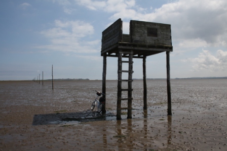
Carrying cargoes of unslaked lime was a dangerous business, expansion taking place and great heat being liberated should water penetrate the cargo but it is reported there were few casualties. However on attempting to weigh anchor one year at the Heugh the anchor was very difficult to break out. On getting it aboard it was caked with white, what I assumed to be an old lime cargo, the surrounding geology being boulder clay. In earlier times Lindisfarne was a hive of industrial activity, the monastery in effect being a medieval industrial estate. In common with most coastal communities the foreshore was a place for disposal of rubbish so the shore below the Heugh and the village holds archaeology. Pottery and tile sherds are the most obvious remains but elsewhere the sea has eroded old rubbish tips. I picked up a Bakelite ladies rouge container of perhaps seventy years ago. To walk in the dunes old clothes are advisable, they will get covered in burrs as will a dog’s coat. These are pirri pirri burrs, annoying for walkers and distressing for animals. One is asked to be careful not to spread them as they are the seeds of a non-indigenous plant, thought to have been introduced from New Zealand. In the dune grassland many a stone covers an ants’ nest, the dry sandy soil being ideal habitat for them. In the surrounding rough grazing in spring and early summer cinnabar moth caterpillars feast on the ragwort. On the north shore there is a beautiful sweep of sand stretching for five miles to Berwick upon Tweed with ribbons of sea coal on the strand line. The coal bears calcareous worm casts, unlike that washed up from the muddy reaches of the upper Forth. Above the beach, at the dune edge small pebbles of deeply honeycombed limestone litter the path, nature’s way of buffering the acidity of the grassland. These are excavated by the numerous rabbits. In the dunes snails cover the paths, liking the lime for their shells, it being difficult to walk without crunching them underfoot. At the north end of the island one finds the Nessend quarry which supplied the lime industry. The different working levels and tramway routes that served them are evident. One can walk right round the island, returning on the causeway. However the causeway tarmac suits a folding bike. One can walk out to the refuges on the Pilgrims’ Way and go up the steps of the one on the bridge for views over The Swad and The Slakes, wild fowling country. Going over the bridge onto the mainland one comes to a line of dragon’s teeth, concrete anti-tank obstacles from WWII, a stark return to reality after the gentle Celtic mysticism of Holy Island.
Lindisfarne wildlife Holy island is a national nature reserve for good reason. Its 8,000 acres of dune land, saltmarsh and mud flats provide a range and richness of habitat that is reflected in the diversity and profusion of the wildlife, much of which can be enjoyed from a boat. An internationally important wildfowl refuge, tradition has it as a bird sanctuary dating back to the sympathies of the seventh century monk St Cuthbert, for many years Prior of the monastery which St Aidan founded on the island around 635. The numerous eider are known as Cuthbert’s ducks. The apparent tameness of this duck on her nest is in fact a reluctance to leave the eggs she is incubating. One should try to keep away from occupied nests but such is the camouflage of her brown plumage and stillness one can find oneself close before noticing the bird on the nest.
Plant life adds to exploring ashore as much is in bloom during the sailing season. I tend to feel that botany books are written for botanists and elementary identification guides suffer from illustrations that are too small. For the money Collins’ Wild Flowers of Britain and Europe (16) does a good job. However being a field guide it is pocket size. Its ‘botany in brief’ pages indicate that the publishers have got the message that a basic identification guide is needed. If you take leaves home for identification, Keble Martin’s The Concise British Flora in Colour (17) is helpful, its line drawings bringing out detail often lost with depth of focus in photographs. Ian Hepburn’s Flowers of the Coast (18) in the New Naturalist series gives a habitat perspective. On the slopes above the shore one will find common scurvy grass, sea campion and sea pink. More into rough grassland there is bird’s foot trefoil and viper’s bugloss. In the village ivy leaved toadflax grows on old walls. Rarities to be found are the Lindisfarne helleborine, Epipactis sancta an orchid only found on Holy Island and the coral root orchid. The nature reserve wardens organise guided walks in the flowering season. Though not wildlife, keeping homing pigeons is a common pastime in the north of England and I have had one aboard at Holy Island. Not having bird seed I put out bread, muesli and water but all it wanted was to sleep under the spray hood and fluffed up its feathers. I now know that it might have eaten uncooked lentils or rice and the water I put out was not deep enough for the bird to drink. Pigeons have to get the beak right into water to scoop it up so it needs to be an inch or two deep. I managed to catch the bird to read its rings. The right handed hold a pigeon in the left hand, palm uppermost, legs between the third and little finger, thumb round the left wing and fingers round the right. This leaves a hand spare to rotate the rings and write down their details. With some web searching this bird was reported. It had been released at Selby, Yorkshire and had got lost on its way back to its loft at Whitley Bay, Tyne and Wear. Again if I had known at the time, this bird had its owner’s telephone number printed on its wing feathers, common practice. The websites of British Homing World and the Royal Pigeon Racing Association give advice on what to do if you find a stray homing pigeon. When this bird left the boat it had not flown home. It was taken in by a pigeon fancier on the island. A repatriation scheme provides for birds to be returned by approved carriers. The carriers supply special containers for the purpose and the bird had gone home in one.
Holy Island as a base for cruising Holy Island is a sheltered refuge from which to explore the Farne Islands and places further south. Seahouses (North Sunderland) might be considered an alternative but the outer harbour where yachts have to lie has very hard ground. Fishing boats occupy the inner harbour. Drying out and refloating there can be an anxious business. It can only be recommended for loading stores from the supermarket on the top of the tide. However its prominent 1770’s lime kilns are older than those at Lindisfarne and Seahouses was the home port of some of the ships that served the Holy Island lime industry. Two more booklets available in the Holy Island shops cover this and other local ports (19,20). The area is steeped in the Grace Darling story and The Grace Darling museum at Bamburgh, run by the RNLI is worth visiting. Less well remembered is the influence the subsequent inquiry into the loss of the Forfarshire had on the regulation of steam ships in those dreadful times for merchant seamen, before Samuel Plimsoll’s Appeal (21). Also almost unknown and all the more remarkable for those times reads the delightful fly leaf of the Appeal, “Dedicated to The Lady, Gracious and Kind, who, seeing a labourer working in the rain, sent him her rug to wrap about his shoulders”. Safety at sea has much improved since those days but great care is still needed when navigating these waters.
References 1. Grace Darling Maid and Myth, Richard Armstrong, J.M. Dent & Sons Ltd., 1965. 2. Children of the Sea The Story of the Eyemouth Disaster, Peter Aitchison, Tuckwell Press, 2001, ISBN 1 86232 240 6. 3. RNYC sailing directions Humber to Rattray Head, 1990. 4. Northumbrian Coastline, Ian Smith, Sand Hill Press, Second Edition 1993, ISBN 0 946098 48 4. 5. The Magic of the Swatchways. Cameos of cruising in small yachts, Maurice Griffiths, Nautical Books, Conway Maritime Press Ltd., 1986 reprint, ISBN 0 85177 385 0. 6. The Magician of the Swatchways. A biography of Maurice Griffiths, Dick Durham, Yachting Monthly, 1994, ISBN 1 85277 096 1. 7. Holy Island, Frank Graham, Butler Publishing, 1987, ISBN 0 946928 13 4. 8. The Holy Island of Lindisfarne and the Farne Islands, R.A. and R.B. Cartright, David and Charles, 1976, ISBN 0 7153 7185 1. 9. Lindisfarne Castle, The National Trust, 1990. 10. The Art of Illuminated Letters, Timothy Noad and Patricia Seligman, Past Times in association with Headline Book Publishing, 1995. 11. A Naturalist on Lindisfarne, Richard Perry, Lindsay Drummond Ltd., 1946. 12. Lindisfarne’s Limestone Past: quarries, tramways and kilns, Roger C. Jermy, Northumberland County Library, 1992, ISBN 1 874020 04 3. 13. Lindisfarne The Cradle Island, Magnus Magnusson, Oriel Press, 1984, ISBN 0 85362 210 8, paperback edition 1985 ISBN 0 85362 223 X. 14. The Birds of Holy Island and Lindisfarne National Nature Reserve, written and published by Ian Kerr, 2003, ISBN 0 9544880 0 8. 15. At the Turn of the Tide, Richard Perry, Lindsay Drummond Ltd, 1938. 16. Wild Flowers of Britain and Europe, Lippert and Podlech, Harper Collins, 1994, ISBN 0 26 16740 3 X. 17. The Concise British Flora in Colour, W. Keble Martin, Embury Press and Michael Joseph, 1965. 18. Flowers of the Coast, the New Naturalist, Ian Hepburn, Collins, 1952 and numerous reprints, ISBN 0 00 213067 X. 19. Bamburgh, Seahouses, Beadnell and the Farnes, A short history and guide, Frank Graham, Butler Publishing, 1991. 20. Walks Around the Old Grain Ports of Northumberland, Alnmouth, Seahouses and Berwick, Editor Tony Barrow, Northumberland County Library, 1995, ISBN 1 874020 11 6. 21. Our Seamen an Appeal by Samuel Plimsoll M.P., London, Virtue & Co, 1873. Paul Shave Blue Spindrift 24 October 2012 |
info@fyca.org.uk
©dss2016