Kennetpans is on the north side of the Forth just upstream from the Clackmannanshire Bridge. Interest in its historic distillery has been awakening as the increasing number of websites demonstrates. It is the birthplace of industrial scale whisky distilling and fitting that it should be preserved. A start has been made. See A Wee Dram at Kennetpans. The news was reported in The Times 22 January 2016 (3).
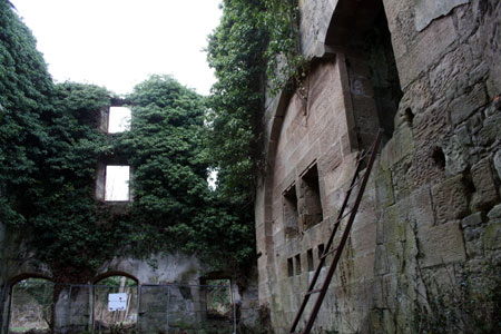
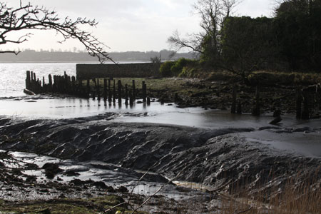
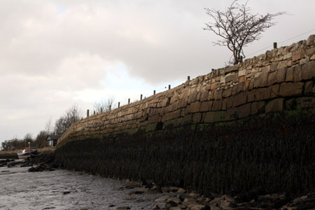
Surviving timbers of the distillery’s west jetty, ironwork, sea defence stonework and huge warehouse walls give a good impression of the size of the former harbour. There was an east jetty but only stumps remain. A local boat berths alongside the sea wall further west. At the south east corner of the distillery building the bow of the steel lifeboat featured in the Kennetpans Trust’s website photograph can still be seen. It is now buried with building rubble as foreshore erosion defence.
The harbour being a ruin and the seawall river berths private no entry for Kennetpans was made in the FYCA Pilot Handbook (4). It describes negotiating the Kincardine Bridge but not the new Clackmannanshire Bridge for which see the Admiralty chart (2). The area is subject to what is called the ‘Leaky Tide’, giving a double high water. Only brief mention is made of it in the Pilot Handbook but is reported that approximately 1 hour before high water the tide reverses for about 1/2 an hour giving in effect four tides some days. The local boat has missed high water required to sit alongside the sea wall only to see the tide return.
A visit to Kennetpans is appropriate for early or late in the season when the upper Forth offers more sheltered waters. It is also worth considering when the mast is down for a Forth and Clyde Canal transit and one is not then hampered by overhead bridge clearances.
A landing is most conveniently made on the beach to the east of the distillery once the tide has covered the mud, an hour or two after low water. The tree covered mound above the beach is a good landmark and once ashore is a handy viewpoint. Formed by sailing ships dumping their ballast its size is quite amazing and the eroded seaward face reveals layers of different materials.
If heading up to Stirling and not wishing to leave the main river channel, the distillery can be viewed with binoculars.
From landward, there is access through Kincardine town on a single track road which is part of National Cycle Route 76, The Round the Forth Route. This section is called “The Cycle Friendly Road”. It passes within 500metres of the site. The distillery is privately owned and access roads are narrow so cars are best left well away, at Kincardine or the lay-by between Kennet and Clackmannan where the sign posted public footpath through Kennet Gardens begins. From here the distillery is a two mile walk. At Kennetpans the turning area is muddy and in use by locals and contractors.
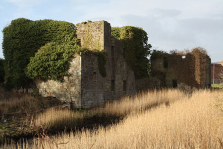
Having been closed for nearly 200years it is remarkable how much of the distillery survives. The building is a potentially dangerous ruin, fenced off and one is asked to respect the owner’s rights and keep out. One can see inside through openings in the structure without entering. An interpretation board is in place and new ones are to be installed by the end of 2017. Removal of vegetation and stabilisation of the stonework is in progress. It is intended that when the building has been made safe and the new interpretation boards erected it will be opened to the public.
The Times article incorrectly reported that it is intended to re-roof the building. The ruin is scheduled and Historic Environment Scotland requires that the building stays in the condition it was on the date of scheduling so it will remain a ruin.
Archaeological investigation of the distillery building was begun last year (2015). The foreshore by the pier and to the east must also tell stories. In particular I noticed pieces of foundry slag and flint. Perhaps the flint was cargo brought in to be milled to make pottery glaze as was done at Bo’ness harbour and Todd’s Mill on the River Avon. Sailing ship ballast no doubt complicates the foreshore picture. Ribbons of shore coal can also be seen, probably washed from the spoil of local mines.
It will be interesting to read what the specialists make of the shore debris, a rare old mixture of building rubble, domestic and industrial rubbish. The harbour probably continued in use long after the distillery closed and sherds of 19 th and early 20 th century pottery on the mud date from this usage and local residents’ depositions. Caution is necessary when walking here. Surfaces are slippery and the mud is deep. Wellies and a stick are recommended.
The distillery is visible from the approach road to the Clackmannanshire Bridge and it will become more so as the covering vegetation is removed. Whichever way one visits, it is a fascinating exploration, a glimpse of our industrial past, its links with agriculture, mining, trade, transport by sea and the application of emergent steam age technology.
References
1. Ordnance Survey Landranger Sheet 65, Distillery Map Reference NS 913889
2. Admiralty Chart No. 0741 Plans in the Firth of Forth and River Forth.
3. The Times, Friday 22 January 2016.
4. Forth Yacht Clubs’ Association Pilot Handbook, Nicholas Thomson, published by the FYCA 1974 and subsequent editions, currently out of print.
Paul Shave
Blue Spindrift
7 February 2016