 |
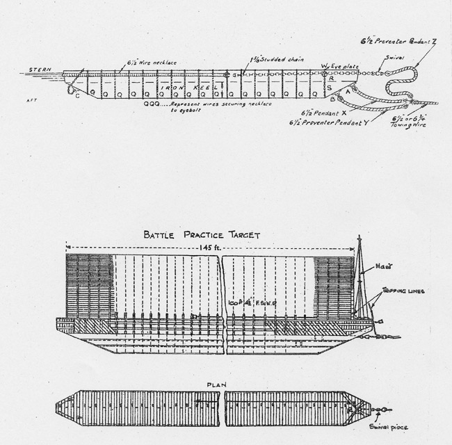
THE BLACKNESS ADMIRALTY BATTLE PRACTICE TARGET
Click here for data sheet (pdf)
In my quest for new places to visit close
to home I thought I might explore the abandoned hulk of an Admiralty
target barge in the bay east of Blackness castle. It is an attractive
spot to lie. The trees come down to the top of the beach, there are views
of the castle and the bridges and much birdlife feeding on the mudflats.
The nautical archaeology is a bonus. Lack of road access makes the site
is quite secluded. The barge hides the silhouette of ones boat from the
curious and gives some shelter from the west but being in poor condition
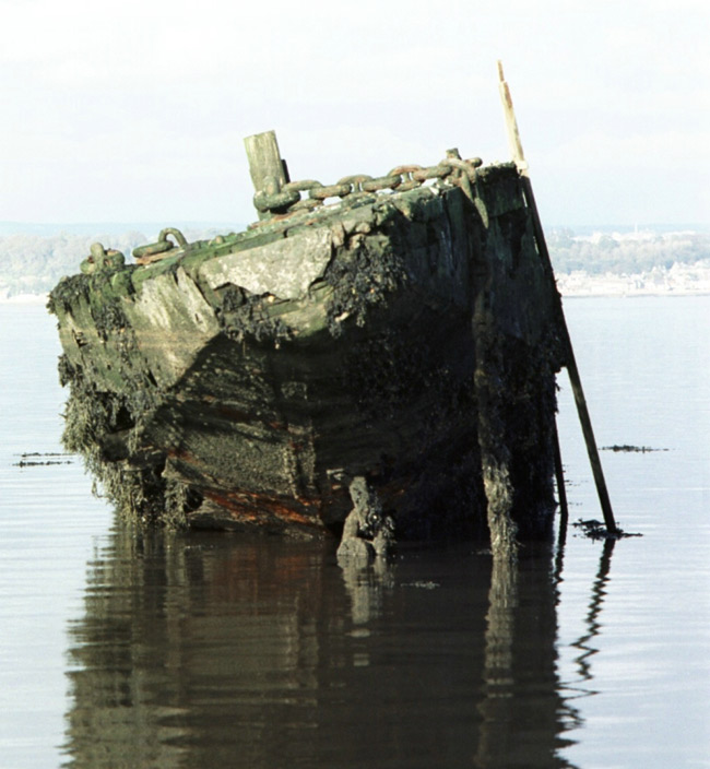
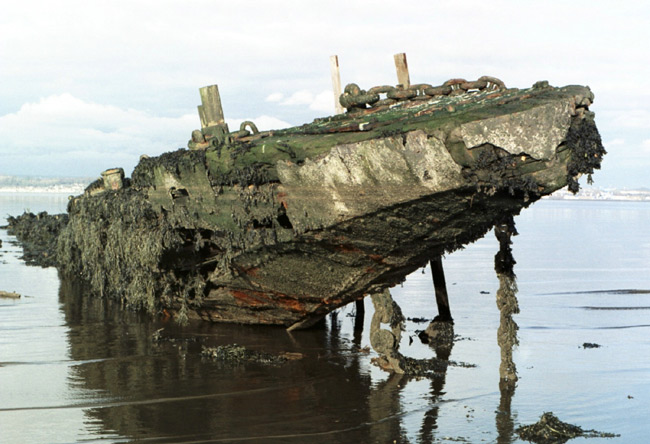
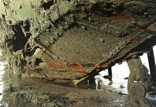
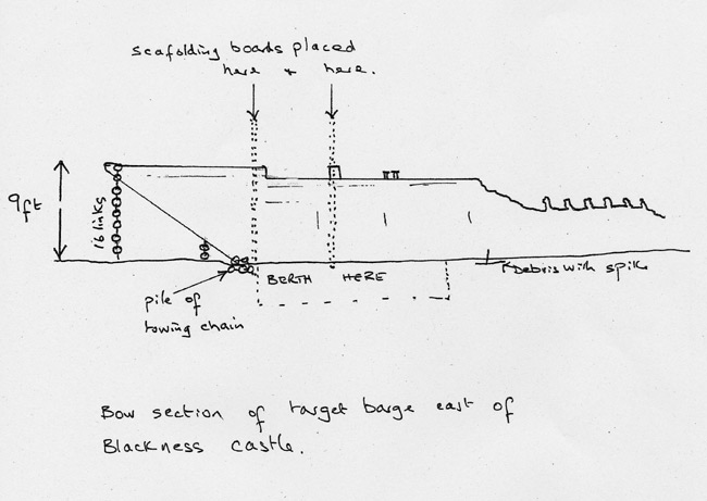
there are dangers. The barge lists to the west so most of the debris field lies in that direction. The sloping deck is green and very slippery. One can lie along the port (east) side of the forecastle head and remaining 25ft of main deck, avoiding a small pile of chain on the port beam and a spike in the mud at the after end of the section of main deck. There are many of these spikes, originating from wasted iron fastenings, exposed where timber has rotted away. Other nearby obstacles are a large stockless anchor with its flukes sticking up and a pole leaning at an angle, both about two cables to the north east. These show at low water. They are not charted but probably lie just within the pecked lines of an exclusion zone for passage and anchoring. When I came alongside at high water on a 5.1m tide ( Leith ) the upper edge of the main deck was just above the water. Going down river on the ebb in the gathering gloom, cold and overcast, going alongside suddenly didn’t seem such a good idea but I p res sed on knowing I had done careful preparation. I lassoed a deck fitting with the bight of a stern warp and ran a bow line to the forecastle head with the dinghy. The wind was westerly, holding me off and remained so. I had taken two pointed 13 ft scaffolding boards. Once alongside I stuck these into the mud vertically and lashed them to the barge so I wouldn’t touch its structure. My initial hurried lash up I later re-tied with nylon so it would last a while. I carry a heavy fender board on Blue Spindrift. Later this was a handy gang plank for boarding the barge. As the tide fell an expanse of calm water spread to leeward. When the boat settled I was listing a few degrees away from the barge, my starboard keel having come down on something, perhaps a stone or piece of plating. Our Vice Commodore told me the barge was beached in the 1950s. By comparison with my boat it is 100 ft long by about 10 ft beam. From the degree of the corrosion of its riveted plating it is probably nineteenth century. Much of its plating has rusted away leaving the internal reinforcement, a massive lattice of wooden cross beams and longitudinal iron girders. Clearly it was built to withstand learner gunnery. The main deck is wood a foot thick and the forecastle head up to three feet thick with plating reinforcement under the deck fittings. Stud link chain hangs from the forecastle head and a towing point on the stem. On deck there are various bits, cleats, eye bolts and a tabernacle. The forecastle head is nine feet from the mud and the vertical 16 links of stud link serve as a handy depth gauge. Before my recce the deck was occupied by eider, one drake and six females. While I sat on the shore watching, waiting for the mud to dry, they sat tight till the last minute, jumping off and swimming away just before the tide receded. When I returned with the boat, cormorants were roosting on the barge. I could hear lots of geese but only saw one, they were probably grazing beyond the trees. The one I saw was walking on the mud guzzling up something on the surface. There were numerous swans and eider at the mouth of the Midhope burn, attracted by the f res hwater. I stayed for the next two tides, taking photographs and snoozing in the sunshine. Taking ones time one notices more. At the west end of the beach columns of sand topped by a crown of turf indicate a zone of erosion and further east banks of shell at the top of the beach, a zone of deposition. I took bearings for a precise position but the barge must have been too magnetic as when I plotted them my cocked hat was small enough but much too far from my EP. I later returned with a GPS which gave 55 0 59’.93 N 003 0 29’.69 W. On the shore there are the rotten remains of two Admiralty mooring rafts and various mooring strong points. After the war many ships lay here awaiting the breakers yards of Bo’ness, Charlestown and Inverkeithing. “Target: Falkirk ” has a picture of U boats at nearby Bridgeness. Also on the shore was an assortment of gas cylinders in various states of decay. No doubt this is due to a combination of local hydrography and the relatively unfrequented nature of the site. I brought two usable ones back in the dinghy but didn’t get much thanks for returning them to the supplier. To judge by the res ponse I received it is not global warming causing sea levels to rise but Scotland sinking under the weight of empty gas bottles. From the middle of the beach the remains of a substantial dry stone structure run out to the low water mark, probably once a low water landing. In the 18 th century there was a tide mill in this bay, I would guess at the east, at the mouth of the Midhope burn. There were other tide mills on the south side of the Upper Forth , one at Pocknave, west of Grangemouth, and one at Higgins Neuk, west of the Kincardine bridge. A little stonework at Higgins Neuk is all that remains of these as far as I can see. Having visited the working 18 th century tide mill at Eling, near Southampton I am on the look out for them in Scotland . The Eling tide mill is not far from the new RYA HQ on the Hamble. Colloquially known as a target barge, my 1932 Admiralty Manual of Seamanship Volume II calls these barge type targets a ‘battle practice target’. Smaller raft targets were known as ‘Targets Pattern V, VI and VII’. BP targets came in various sizes. The Manual is illustrated with drawings of one of 145 ft LOA with two towing pad eyes on the stem, reproduced here. For ocean towing of BP targets the towing warp was attached to three pendants, two to the stem and one to a necklace of 6 1/2” wire that ran all round the gunwhale so the tow would not be lost if the bow was shot away. There would have been another towing eye on the stern so that targets could be strung together. Speeds of around 10 knots were usual. The raked stem, low attachment and special flexible wire would permit higher speeds and 16 knots was obtained towing with a battleship. The tow was up to 1,000 yards long but doubtless the target felt quite close enough when being shelled from 16,000 yards at night. One begins to admire the skill involved in towing, in particular the matelot handling long wi res round bollards and capstan. The manual shows a mast and one can see its tabernacle but the tow was unlit. The tug had to be ready to shine a search light to illuminate the tow on the approach of other vessels. The target carried a sail of open weave lattice work of black hessian strips up to 30 ft high. This comprised upper and lower sections. To prevent capsize in strong winds only the lower sail would be used. A painted strip at full height of the mast assisted ranging. This was an inte res ting exploration and a most welcome addition to the list of trips close to home. Berthing alongside is for bilge keelers with local knowledge. It could be a dangerous trap in an easterly. A shore side low water recce is preferable to surveying from a dinghy as one needs to see the area dried out. An inflatable dinghy would be vulnerable to sharp debris. Details of this target have been passed to the Royal Commission on the Ancient and Historical Monuments of Scotland and the vessel is now listed on their database, with photographs. See entry NT07NE 8003 within their CANMORE public access system at www.rcahms.gov.uk An archaeological survey is on the cards. References 1. Target: Falkirk, Falkirk and District in the Second World War by John Walker, Falkirk Council Library Services 2001, ISBN 0906586 925. 2. Admiralty Manual of Seamanship Volume II 1932. Paul Shave yacht Blue Spindrift 29 December 2004 |
|
|---|
©dss2006
info@fyca.org.uk
©dss2016