 |
KINCARDINE,
Kincardine narrows and Higgins Neuk
Forth cruising has much to offer but it is tempered by the relative paucity of shelter from the East. Watching the waders feeding on the mud is an attraction but with the wind in the East a night on my mooring at Bo’ness is to be avoided. The closest alternative shelter is Bo’ness outer harbour but for more wildlife and foreshore history Kincardine beckons. Heading up to Kincardine the river turns to the North West providing some measure of the elusive shelter from the East. On immediate acquaintance, the panorama of one of the largest refinery complexes in Europe, traffic thundering over the road bridge, brightly painted blocks of high flats and a towering power station would not appear encouraging but give the place a chance and there is much of interest and a rich historical past. Besides waiting here for clearance under the bridge, Kincardine has become a convenient anchorage for the Forth and Clyde Canal entrance on the River Carron, especially as there are town centre facilities closer to hand than on the Carron. A future reason for getting to know Kincardine may be to watch the construction of a new Forth road bridge. Three hundred yards east of the town pier is a small outfall pipe in line with an electricity pylon at a dog leg in the run of the wi res . I anchor east of the pipe, there is less risk of picking up old mooring chain than closer to the bridge. Anchoring off promises freedom from tending warps and fenders and more peace and wildlife. The approach to the town pier has the added concern of avoiding the running moorings of fishermen’s dinghies. The bottom is thick mud and with my Bruce anchor I am assured of good holding, something to consider on a spring ebb with the river current behind it. Watching the ebb sluicing past the anchor chain one realises the pull on it. Keeping the boat clean when weighing a muddy anchor and chain in silt laden water is another matter but is manageable if a little freshwater can be spared. A few colourful fishing boats lie on moorings off the town pier. These move into the main stream to fish with beam nets. The Forth is a salmon and sea trout river but these boats fish for whatever else there is, netting not being an approved method to take salmon. The bailiffs of the Forth District Salmon Fishery Board keep a good look out for unauthorised fishing. Once the noise of anchoring is over, keeping quiet and out of sight will soon bring the birdlife back to feed along the water’s edge. In the early morning and evening grey herons stalk the shallows. Sprats and sparling (smelt) stocks have been recovering though one wonders how a heron can see them, the water is so muddy. Giving the boat a sheer in the river current so that a corner of the cockpit is sheltered, keeping out of sight is not a hardship stretched out sunbathing in the shelter of the dodgers. As the tide falls one begins to appreciate the scale
of the stone clad embankments on the north side of the river. The first,
to the west of the bridge, was built between 1820 – 22 and is 2,020
yards long. That to the east is 3,040 yards long and was built in the
years 1829-38. Both are faced with quarried stone blocks. The west is
harder stone and at some later date has had the joints between the blocks
sealed with pitch and been extended upwards with concrete blocks. The
east embankment has had only minor repairs and is in need of some refurbishment.
The softer sandstone here is weathering and patches of blocks are out
of place but it is a remarkable structure that gave much needed work
to quarrymen, carters and labourers. Around 200,000 blocks would have
been used on the east section alone.
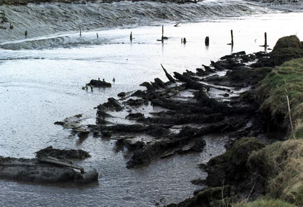
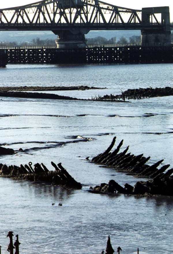
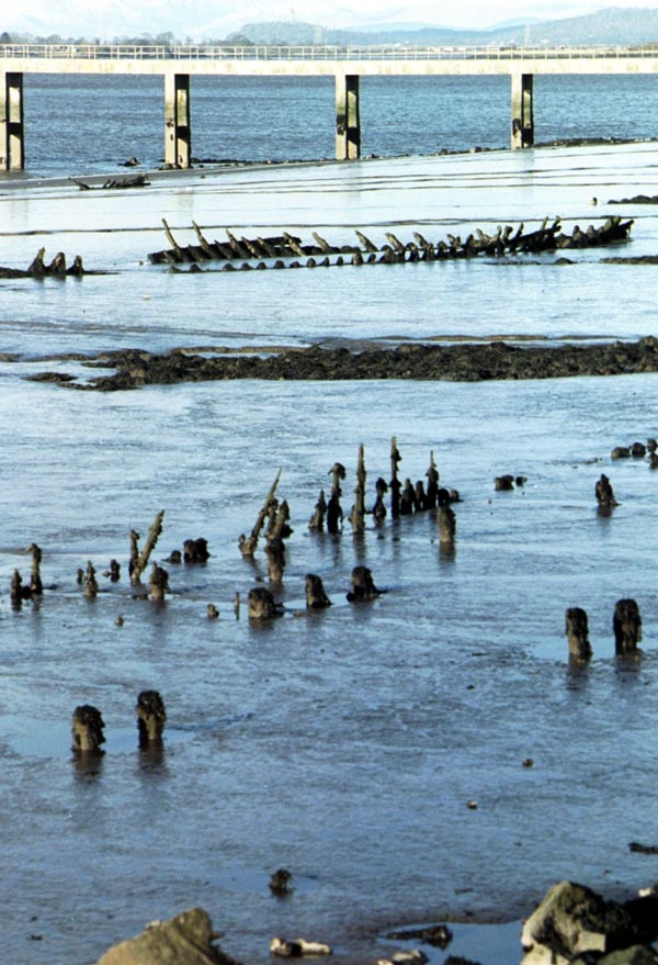
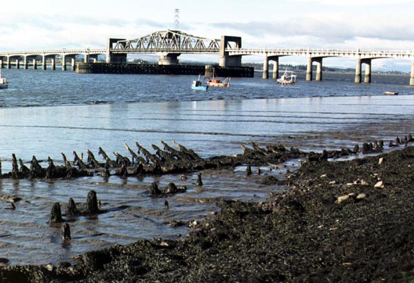
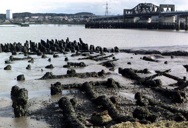
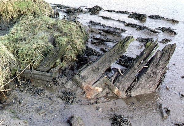
As the tide falls further the Kincardine ship graveyard begins to reveal itself. This comprises the bones of around twenty 19 th and early 20 th century vessels and foreshore structures . They were mainly fishing boats and may also have included a cattle ferry. These remains and the maritime history of the area are described in the Shipwreck Heritage of Fife 1. Some information may also be found on the Gazetteer for Scotland web site 2. On the east side of the bridge one can see the frames of six wooden boats and rows of foreshore staking, perhaps remains of a former jetty. To the west are the timbers of some larger boats and more elaborate foreshore structures . West of the ferry slip is a rubble causeway leading to a fishing bank. Here in the 17 th and 18 th centuries salmon traps called cruives were placed. This is an important archaeological site as little is known of cruive fishing, especially in the Forth . Continuing west is one of the larger ship skeletons, possibly the twin ruddered cattle ferry, Oceanic or Ossianic in service 1828-35. It is thought she was abandoned when the two steam tugs that towed her moved to the ferry crossing at Alloa. Along the shore here is a double row of stakes that were probably part of coastal defences, pre-dating the stone clad embankments. The great days of ship building at Kincardine were the latter part of the 18 th century and no sign is evident but remains of the ways may yet be found to the west of the town in the Kennet Pans inlet. The Fringes of Fife 3 makes disparaging remarks about Kincardine but the town has always enjoyed a measure of prosperity from its location at a strategic crossing point of the Forth . Curiously Ferries in Scotland 4 has plenty to say about neighbouring Alloa but is silent on Kincardine. There is evidence for the use of Kincardine as a ferry crossing point from the 16 th century until the swing bridge was built by Alexander Gibb & Partners (1932-1936). This was the earliest road crossing over the Forth East of Stirling and the world’s largest swing bridge. The River Forth 5 gives detail of the operation of the bridge. It was exceptionally well engineered and very efficient to swing. The substantial sandstone ferry slipway west of the road bridge is used by local fishermen but has a locked gate. Kincardine is a colossal maritime archaeological resource and the remains so evident at low water are a fascinating diversion to anyone seeing the tide round. The public library has some interesting documents on the shoreline structures 6&7. With the construction of the new eastern link road, access
to the foreshore, pier and slip is now over a railway level crossing
250 yards west of the bridge. The short walk to the town is rewarded
by the menu at the Unicorn which includes good seafood. Other facilities
include more pubs, a bank, Post Office, chemist, filling station, grocery
stores , hardware shop, various takeaway foods, tackle shop and newsagent.
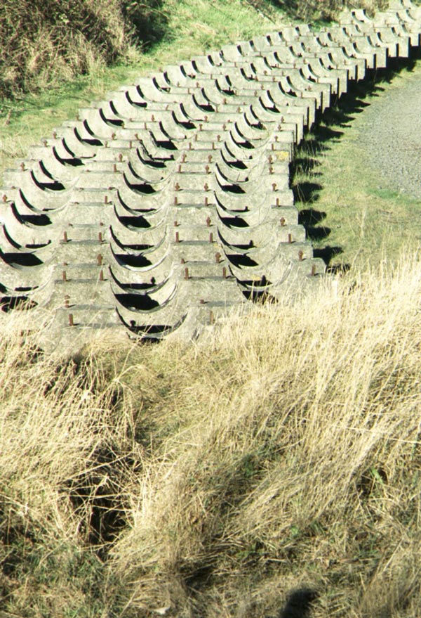
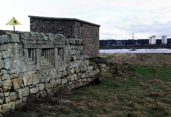
The last colliery in the area has closed and with it the Kincardine power station, the site of which is being cleared and is on the preferred route for the new Forth bridge. A row of strangely shaped concrete blocks stretches along the foreshore. These supported pipes that carried a slurry of boiler ash (fly ash) from the power station to settling ponds on Preston Island where the resulting sediment was used for land reclamation. Ash from Longannet power station has been disposed of in the same way and is now being used to manufacture building blocks. The main Scottish Power pier West of the bridge can be used near HW. A hundred yards West of the pylons crossing the Forth is another concrete pier. One must keep clear of this. It was the water intake for the Kincardine power station and dangerous obstacles, the water strainers, palisades of rolled steel joist, lie off it. Above the Kincardine narrows the wide expanse of river, open saltings and the Ochils in the distance contrasts with the more enclosing industrial scene down river. The scene is framed by huge pylons carrying wires over the Forth , their structure worthy of examination with binoculars. The wires serve to estimate the cruising altitude of the skeins of geese that fly overhead. On the South side, half a mile up from the bridge, the Pow Burn joins the Forth . The undercut banks display the river’s powers to erode the aluvium and a series of sea defences from stone wall to vestiges of wooden palisades contour the view. The road curves round a lost meander, now a rush filled depression, physical geography in action. Groups of cormorant and duck sit on the edge of the saltings watching the river, waiting for tide to fall while overhead the geese call continually and change formation. Field boundaries strewn with rush stems betray the extent of the inundation of the area on high tides. It was here during the years 1507-1513 that King James IV of Scotland established a dockyard. The precise location of the three docks is a matter of conjecture but local historian John Reid has surveyed the area and is continuing to investigate 8. Various inter-tidal timber structu res are possible indications and confirmation is being sought. Viewing the scene from ones boat it is easy to see the attractions of the site. The area was a lot more defensible than lower down the river, it is more sheltered and the saltings easily dug into for crude dry docks. John’s researches show the area was already owned by the Crown. There was a tide mill on the Pow, pronounced Poo. Possible traces of the mill, a lost meander, jetties, and boat timbers are to be seen but so many changes have occurred at this busy ferry crossing, including a radical shift in the shore line, that making sense of the archaeology is complicated. One boat skeleton in the Pow Burn could have been a ferry. It has a very flat bottom and from the lateral position of the remaining rudder it appears there were two, similar to the Oceanic. Unlike the North side, the ferry slipway on the south was a timber structure. Lower down the the foreshore mud a mass of piles can be seen and higher up some cross members and timber decking. Two very substantial stone walls run down in the direction of the slip, stopping some distance short for want of solid substrate. Both these walls were later fitted with pre-cast concrete loopholes to create a defensive position, looking up and down river. One has to remember that not much further up river was the fleet ammunition depot at Bandeath. This conversion probably dates from the First World War as the Kincardine bridge and its approach road embankment block the eastward field of fire. Prior to construction of the bridge it would have been a commanding position. Walking these saltings on a fine bright February morning, snow on the hills, magnificent flights of geese overhead and occasional shots in the distance one understood how the yachtsman could take to wild fowling in the winter months, just as Davies and Carruthers in the Riddle. Passing a bird watcher carrying his telescope and tripod, reminded how times have changed but much of interest is here if one is prepared to look for it. That is the essence of the area and its defences. You have to work to read the place and discover its secrets. Thankfully solitude is assured by the need to walk, the obstacle course of gullies and the softness underfoot. The ugliness of distant industry, strandline plastic and roadside litter doesn’t bother the birds. They look as majestic as they would have done when the industry here was James’ caravelles on the stocks, the air full of the sound of the adze and saw pit.
References: 1. Shipwreck Heritage of Fife , Neil Cunningham Dobson, March 1997, Fife Council 2. http://www.geo.ed.ac.uk/scotgaz/towns/townhistory43.html 3. The Fringes of Fife, John Geddie, W&R Chambers Ltd, London and Edinburgh , 1894, revised 1927. 4. Ferries in Scotland , Marie Weir, John Donald, Edinburgh , 1988. 5. The River Forth , William F Hendrie, John Donald Publishers, Edinburgh , 1996. 6. Report of the Embankment and Ferry Piers on the Estate of Tulliallan near Kincardine, in Clackmannanshire, 1838. 7. River Forth Crossings. Joint Report of Mott, Hay and Anderson & Sir Alexander Gibb and Partners to the Ministry of Transport August 1930. 8. King James IV dockyard – an update, by John Reid, Falkirk Historical Society, talk to Bo’ness Town Trust February 2005. 9. Numerous websites on the next Forth road crossing e.g. http://www.forthbridges.org.uk/news.htm
Paul Shave Yacht Blue Spindrift 22 March 2005
|
|
|---|
©dss2006
info@fyca.org.uk
©dss2016