 |
FORTH ANTI-SUBMARINE DEFENCES This is the beginning of a series on Forth fortifications and thanks are due to the UK Fortifications Club http://www.ukfortsclub.org.uk/ for access to their research. The foreshore remains of the Forth anti-submarine/anti-torpedo boom complement the miniature submarines on the shore at Aberlady, providing the Forth with examples of defensive and offensive submarine warfare. In the outer Forth, on the Isle of May are some of the buildings used by the Royal Navy for its anti-submarine indicator loop defences in the Second World War and the submarine wrecks round the island are a further reminder of the threat. For the sport diver these have become more accessible with the increasing availability of the oxygen enriched mixture NITROX and GPS. There are four First World War submarines, the U-12, probable UB-63 and our own steam powered K boats, K-4 and K-17 in 46-55metres. The K boats were casualties of “The Battle of the May Island”, 31st January 1918 (References 1 & 2). The Forth Boom
|
|
|---|---|
Cramond Island
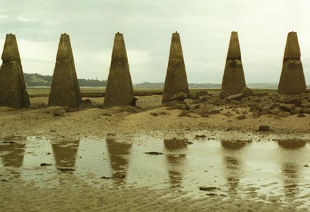
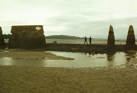
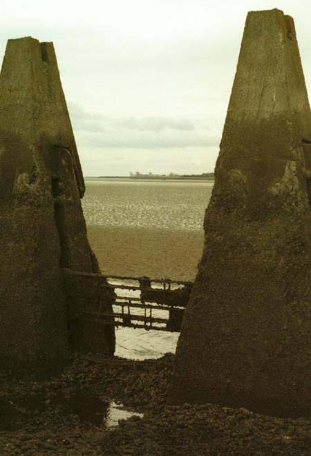
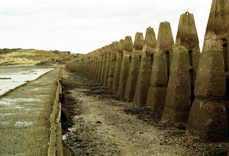
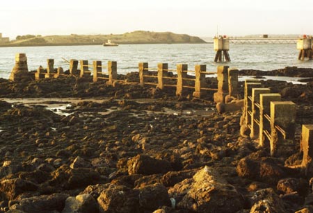
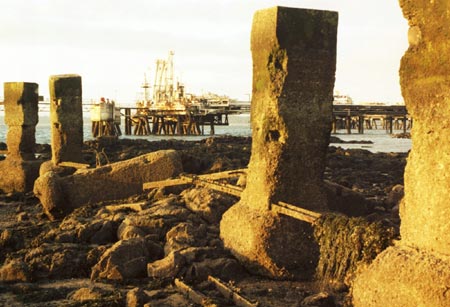
Forth yachtsmen are familiar with the foreshore concrete pillars between Cramond Island and the mainland. The FYCA Pilot Handbook and the Cramond Boat Club year book give directions for passing through an enlarged gap between them. A white painted arrow points to the gap. Seen at low water this is a very impressive line of obstacles. They have vertical grooves in their sides into which were slotted reinforced concrete panels, a few of which still survive. The panels completed the barrier and provided shelter for the causeway, narrow gauge railway and other services immediately to the west. Each pillar had a ring on the top to locate a wire.
|
|
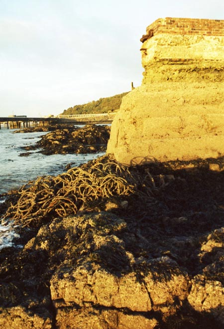
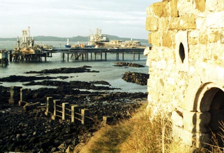
Charles Hill
Less well known, at Charles Hill there are much more technically
interesting remains. Here there are concrete foreshore pillars and heaps
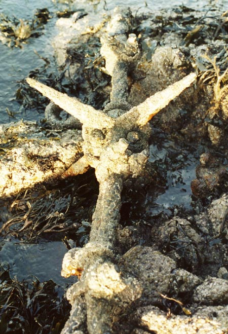
of the boom netting and other components. These include short lengths
of heavy steel wire top rope bearing a cross of spikes designed to rip
the bottom out of surface skimming raiding craft. |
|
 |
 |
 |
 |
|
The boom netting at Charles Hill is Second World War type, made of 18 inch diameter interlocking rings of half inch steel wire of laid single strand. This was anti-torpedo as much as anti-submarine. Elsewhere, probably to fit the shore gradient, the net was square mesh and held together by bulldog grips. Netting of both types can be seen. The boom, with its opening sections to allow for the passage of ships, was clearly quite a complicated structure. This can be seen from the variety of wire diameters, assorted components and short lengths of chain on site. The rocks on the shore are slippery with weed and sharp single strands of wire stick out to catch the unwary. The remaining net was bundled up years ago either for delivery or removal. The steel would appear to have survived so well being protected by a heavy concretion of barnacles. |
The row of piles in the bay to the west was not part of the boom. They were the supports for the sewage outfall from the military camp on the Point. There are small craft anchorages around Charles Hill away from the Braefoot jetty in shallow water, unreachable by jetty traffic but special care is needed as this is a rock infested coast. However for the low water one needs to see the boom remains the charted drying outcrops are visible, assisting pilotage. Landward access is via the A921, taking the Braefoot Oil Terminal road going south from the large roundabout west of Aberdour. Park in the Terminal car park (NT 182 838). A short walk over the golf course takes one to the Point. |
|
Inchcolm Island
On Inchcolm island a boom attachment point on the south east corner is quite prominent. A short length of heavy chain protrudes from an anchorage formed from the natural rock supplemented with sandbags filled with concrete. The position of a 40mm Bofors gun covering the boom can also be found here. See the sketch map in the information sheet “Inchcolm at War” and “Inchcolm Abbey and Island ”. |
|
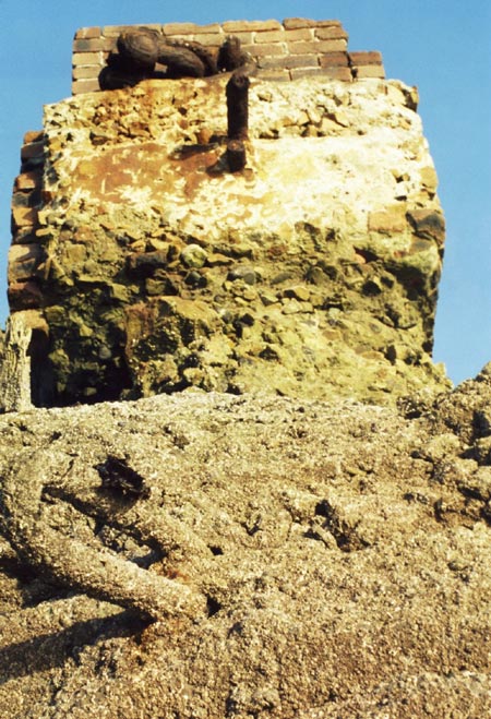
Boom history Most of the boom concrete dates from the First World War. Admiral Viscount Jellicoe makes brief mention of the boom in The Grand Fleet 1914-1916. The design was that of Lieutenant Bircham RNVR under the command of Admiral Sir Robert Lowry, the Commander in Chief of the coast of Scotland and was fitted in place by the end of October 1914. Not surprisingly, given its defensive importance, even in 1919 Admiral Jellicoe was saying nothing of its detail beyond remarking that it was entirely successful. However one can see that the lower pillar at Charles Hill was further built up with brick, probably during the Second World War. The boom was maintained by a shore depot within Rosyth
Royal Naval Dockyard thought to have been HMS Safeguard. Pictures of
large heaps of net at Rosyth and deployment of the boom can be seen in
William Hendrie’s “The Forth at War”. A book that brings
home the enormity of the importance of these long derelict Forth fortifications
is “The Fighting at Jutland ”. Further Naval colour was added more recently by the obituary in The Times of Captain Henry Fancourt DSO, the last surviving participant in the battle of Jutland who died on 8 January 2004 . The text is a picture in itself and is illustrated by William Lionel Wyllie’s magnificent painting of the battle. The Monk’s Cell, Charles Hill Above the boom at Charles Hill is the “Monk’s Cell”, a lovely old stone building that was possibly used by the monks as a store for goods they were ferrying to and from the island. At least that is the accepted view. From a practical standpoint I would have thought a store lower down would have facilitated movement of goods with less effort. The building is dug into the cliff behind and has a well constructed vaulted roof. The alternative name for the site is Vault Point. Unfortunately unless something is done the roof will collapse due to vandals removing stones. That someone would extract stones from a vaulted ceiling when underneath the structure beggars belief. The building is in the care of Historic Scotland and their resources are not limitless. Perhaps some local people might recognise this treasure on their doorstep and do something about it before it is too late. During the Second World War years the Monk’s Cell was used as a magazine for signal rockets for the observation posts. From this vantage point there is a fine view of Inchcolm Island and the Abbey. Outer Forth Indicator Loops Anti-submarine indicator loops are circuits of sea bed cable which were placed at strategic locations to monitor the movements of surface ships and submarines. A vessel even if de-gaussed had sufficient residual magnetism to induce a transient current in the loop. The current was detected by sensitive galvanometers at a loop control station ashore. The pulse of current would cause the needle of the galvanometer to swing and one supposes that the needle was wired to an alarm. Later two loops were used enabling the vessel’s speed to be estimated. One imagines there may have been some means of pen recording as in a barograph. The technology was developed at HMS Osprey, Portland , Dorset beginning in 1915 and first used at Scapa Flow , Orkney. In those days it was probably highly secret, Admiral Jellicoe made no mention of it in The Grand Fleet. On the Isle of May the loop control building in Fluke
Street near the Loch (NT 657 993) was demolished in 2004 but its
foundations remain. The generator hut and operations room are still standing.
For further information, chartlets and pictures see Dr Richard Walding’s
excellent web site: http://home.iprimus.com.au/waldingr/mayisland.htm The indicator loops were supplemented by asdic, the transducers being controlled from the island. Asdic was employed when potentially hostile traffic had been detected by the loop. Anti-submarine trawlers were on hand to deal with contacts but no enemy submarines penetrated the Forth throughout the war, though there were frequent false alarms. The Royal Naval Air Station HMS Jackdaw close at hand at Crail would doubtless have provided support. See the web site: http://www.controltowers.co.uk/C/Crail.htm for further information and excellent photographs. References 1. Shipwrecks of the Forth , Bob Baird, Nekton Books, 1993, ISBN 1 897995 00 8. 2. The K Boats, Don Everitt, George Harrap & Co
Ltd., 1963 and New English Library Times Mirror editions. 3. The Grand Fleet 1914-1916 Its Creation Development and Work, Admiral Viscount Jellicoe of Scapa, Cassell and Company Ltd, 1919. 4. The Forth at War, William F. Hendrie, Birlinn Ltd., Glasgow , 2002. ISBN 1 84158 183 6 5. The Fighting at Jutland, MacMillan & Co., Ltd., 1921 6. The Times Tuesday January 13 2004 , Obituary of Captain William Henry Fancourt DSO. 7. Inchcolm at War, information sheet published by Historic Scotland. 8. Inchcolm Abbey and Island , Historic Scotland and HMSO, (the island guide book), ISBN 0 11 493493 2.
Paul Shave yacht Blue Spindrift December 2005 |
|
info@fyca.org.uk
©dss2016