
WESTERSHORE NAVAL REMAINS AND AN UPDATE ON THE CONDITION OF THEADMIRALTY BATTLE PRACTICE TARGET BARGE (February/March 2016)
Westershore, the foreshore between Blackness Castle and the Midhope Burn, has much of archaeological interest. Besides Naval remains, to the SE of Blackness Castle one can see the ruin of the 2-3 metre wide dyke that retained water for a post medieval tide mill. Stones join up the outcropping bedrock. Various other ruined dykes run seaward, formerly low water landings or access to stake net fishing. Wooden fence posts running seaward were part of a foreshore grazing enclosure. Nearer the Midhope Burn, well out on the mud, are tubular steel posts from a former stake net fishery.
When berthed on Blackness Pier a Westershore walk is one of the attractions of the locality. A low water foreshore recce facilitates drying out a bilge keeler, acquiring the local knowledge to avoid the uncharted obstacles. A quiet night can be had on this usually weather shore, fringed by trees, away from road and river traffic.
Naval mooring remains
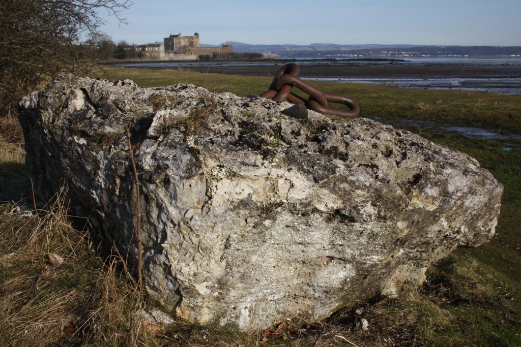
From Blackness, crossing the Black Burn and walking east along the turf of the upper shore one comes to a large lump of concrete sprouting stud link chain, a mooring point. Following each of the two world wars this bay was a park for ships and U-Boats awaiting the breakers. Target: Falkirk(1.) has a photo of U-boats at Bridgeness, Bo’ness awaiting the cutting torch, typical of the scene at Westershore.
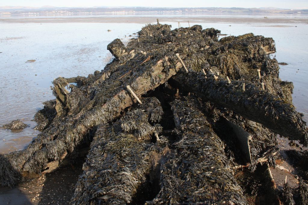
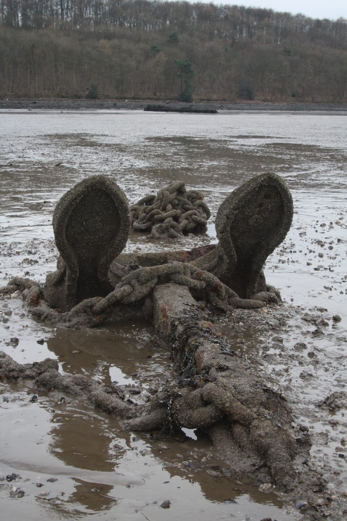
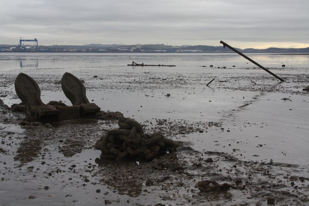
Continuing east the Admiralty battle practice target barge is the prominent composite, wood and iron, wreck skeleton in the mud. To its NE the flukes of a large Byers Admiralty pattern stockless anchor stick up and to the west of it a heap of its stud link chain cable (anchor manufactured by W.L. Byers & Co Ltd, Sunderland)(2). To the east of the anchor a tubular steel pole leans westward, perhaps intended as a marker for it. The pole marks the anchor but covers on high tides, something else for small craft to avoid. At the high water mark lie some much decayed timber remains with deck fittings. Given their timber similarity, fastenings and proximity to the target barge, one assumes sections of its main deck.
Odd bits of steel wreckage can be seen near the anchor, formerly in an exclusion zone on charts. This is an area to be wary of in thin skinned small craft. The target barge in particular has many large bolts pointed by corrosion sticking up to catch the unwary.
Further towards Midhope three angle iron stakes in the foreshore were a holdfast for mooring. The top of the front (lower) one was attached to the bottom of the one behind in succession, multiplying their holding power.
During the Second World War years when much of the upper Forth was a controlled area the shore was littered with Naval equipment. Odd bits of it remain elsewhere today, such as the enormous concrete rollers by the East Kerse, Bo’ness coastal track and boom defence remains described in the cruising guide.
The Admiralty stockless anchor and exploration on the mud
I was curious why the flukes of this anchor stick up when they are designed to dig into the ground. Besides, the cruising yachtsman wants to know what else might foul his anchor or damage the hull when taking the ground.
On 10th March 2016 low tides provided the opportunity to venture onto the mud to investigate. On a cold winter morning this didn’t seem such a good idea but I had thought it out, prepared and had some knowledge of the ground from looking at the target barge. Over the years I have been on mud in the mooring area at Grangepans, Bo’ness which is really soft on account of the dumping of dredging spoil. At Westershore a mud horse was not necessary and would have dragged on the mussel shells.
With a staff, wearing mud boards and with a spare one in my pack I was able to walk out to the anchor. Mussel shells lie on the firmer ground. Water lying on the mud surface indicates softer patches. If tempted to go on the mud, read up about moving on it and prepare. Walkers and cyclists frequent the Westershore Wood carriage drive track, part of National Cycle Route 76 The Round the Forth Route, but on the foreshore one is very much alone. Trees shield the view of the bay from the track. Besides getting stuck, the principal danger is sharps sticking up from the mud. One gets muddy but several fresh water streams flow over the shore for cleaning up afterwards.
At first glance the anchor appears foul of its own cable. In fact the chain isn’t jamming it. The answer is that the anchor was simply dropped, the chain cable running over the stock and falling in a heap close-by. When a stockless anchor is laid the crown touches the ground, flukes pointing upwards, the shank then falls to one side or the other. It needs a pull on the chain cable to set it. If the flukes are pointing upwards, when the anchor is dragged its crown catches the seabed rotating them downwards. Continuing traction causes the flukes dig in. The Admiralty Manual of Seamanship describes the process(3). This anchor was probably part of a mooring network as ropes run out from it to the NE and a mooring was formerly charted in the bay. This may account for why the Navy has not recovered such a valuable item.
During this exploration I was finding my feet, quite literally so did not follow the ropes from the anchor seawards where the mud would get softer. I had enough to explore in its locality and feeling ones way cautiously minimises risk. The mud can’t be that soft however or the ropes would not be visible on the surface.
It was a low tide (0.4m Leith) and the ground firm enough to be able to move about and examine the other remains. The anchor is high and dry on a 1.2m low water (Leith) so I had time. One needs plenty of time in hand as the mud shelves so gradually the tide comes in very quickly once it turns. Whilst the tide obliged, unfortunately the sunny weather forecast didn’t materialise.
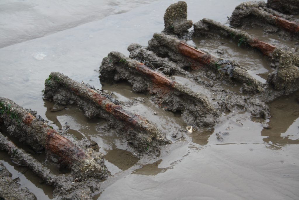
The skeletal remains to the NE look like a dredger’s bucket chain, although very small for that purpose. Perhaps they are bunker coal handling machinery, part of a shell lift or caterpillar track. If anyone knows its function the author would be interested to hear.
Ship breaking
It looks from the debris field in this bay that ship breaking took place here, not just mooring. In all probability a start was made at Westershore before the hull was moved to a breaker’s yard at Alloa, Bo’ness, Charlestown, Inverkeithing or Rosyth. Geoff Bailey gives a thorough treatment of one of the nearest, P.&W. MacLellan ship breakers, Bridgeness, Bo’ness in his Forth Front(4). This book adds a lot of interest to explorations of the upper Forth.
Removing some upper works would make sense, increasing stability and reducing the vessel’s draft, important when running a ship up the beach at MacLellan’s for dismantling. The higher up the shore the ship could be beached, the easier the cutting up of the bottom of the vessel.
Small pieces of plate, wire rope and chain were seen but no sign of any ordnance. Ammunition was removed from ships to return it to stores for re-issue, to recover brass shell case and for safety. It would have been tempting for the burners on encountering missed oddments to toss them over the side to avoid clearance delays so some may remain in the mud. Most old unexploded ordnance is quite safe if left well alone. Danger comes from its disturbance, from mechanical and thermal shock and drying out.
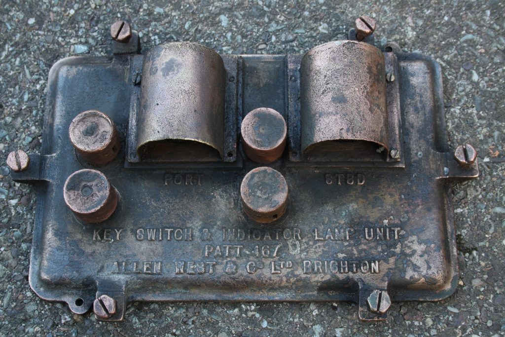
Near the anchor was a small round hatch cover with an Allen West & Co. Ltd(5.) key switch and indicator lamp unit cover lying on it. This heavy brass panel is of such quality that although soaked in seawater for more than 50 years, encrusted with barnacles and plastered with mud the press buttons for ON/OFF still worked, the lamp glasses were intact and the attachment screws freed off. Being a sealed weather proof panel with hooded indicator lamps it probably controlled electric motors from an open bridge, perhaps hull ventilators or any of the legion of pumps in a ship. Such an interesting item waiting to be picked up is indicative of how infrequently anyone ventures this far out on the mud, possibly nobody since the last stake net fishery ceased operation.
Mr Allen West was a key figure in British electrical engineering development, starting the company in 1910. At one time 3,000 people worked for the firm with representatives all over the world. One of Allen West’s first contracts in 1911 was with the Admiralty supplying electric motor control equipment. It is no surprise that equipment of this quality was an Admiralty choice for warships.
Allen West’s part in the war effort of two world wars makes interesting reading. The firm’s history(5) has photographs and woodcut style drawings of the armed services in action, indicating company’s close ties with the forces. A management buy-out since 2007, now Allen West Brighton Ltd., the company still develops and supplies motor control and distribution equipment. It operates a comprehensive spares service that includes support for equipment in Royal Naval vessels.
The Admiralty battle practice target barge
Following the collapse of the bow of the target barge in 2003/4 deterioration has continued. The last remaining section of main deck has become detached from the frames and slid a few feet westward. Visiting in February 2016 it was possible to walk the length of the barge on its east side wearing Wellington boots. On the west side the mud was too deep for this. When visited 2007 it was necessary to wear mud boards simply to reach the wreck. Perhaps this is due to winter gales clearing the mud from the east side.
Since 2004 when I berthed Blue Spindrift alongside the barge foredeck there have been big changes. The photos taken in 2004 and the 2007 and 2016 updates show the progressive degradation of the wood and iron plate, history disappearing before your eyes. Sadly the collapse of the bow removed a high water roost where one could often see cormorants drying their wings.
Other attractions
This is a relatively little frequented stretch of Forth shore. The eastern half is especially isolated as the large pebbles of the shore are awkward to walk on and there is an easier alternative shore route, the track in the trees. Wildlife and beachcombing are its other attractions. The habitat and lack of disturbance makes it a wildlife refuge. As soon as I had walked past the target barge two shelduck were busy skimming the surface of the mud. Nearer the Midhope Burn the birdlife is much more diverse and numerous, attracted by the freshwater and green weed. Upper Forth tidal streams mean that baulks of timber, gas cylinders and other heavy items get stranded along the east half of the bay.
Westershore and Rosyth Naval base opposite have been busy building and dismantling warships for the past 100 years while higher up is the serenity of Abercorn church, a site of Christian worship for 1,500 years.
Midhope Castle, a C16th tower house and doocot are a little over half a mile to the south of the bay. The castle is a ruin surrounded by estate buildings.
The tower on the skyline, visible from the water, marks the position of the House of the Binns built by General Tam Dalyell (1615-85), now in the care of the National Trust.
References
- Target: Falkirk, Falkirk and District in the Second World War, John Walker, Falkirk Council Library Services, 2001, ISBN: 0906586 925. (Page 64 for U-Boats off Bridgeness, Bo’ness awaiting the breakers.)
- Anchors, N.E. Upham, Shire Publications Ltd, 1983. Shire Album 101. ISBN 0 85263 636 9. (Has a bibliography of eighteen titles on anchors.)
- Admiralty Manual of Seamanship 1964, Volume 1. Consolidated edition 1972.
- The Forth Front, Geoff B. Bailey, Falkirk Local History Society, 2013, ISBN 978 0 9560480 5 9.
- The Allen West Story, 1910-1960, published by Allen West & Co. Ltd., 1960.
Paul Shave
Blue Spindrift
23 March 2016